IMAGES TAKEN NEAR TO
Graig Y Hendre, TREHARRIS, CF46 6SG
Introduction
This page details the photographs taken nearby to Graig Y Hendre, CF46 6SG by members of the Geograph project.
The Geograph project started in 2005 with the aim of publishing, organising and preserving representative images for every square kilometre of Great Britain, Ireland and the Isle of Man.

There are currently over 7.5m images from over14,400 individuals and you can help contribute to the project by visiting https://www.geograph.org.uk
Image Map
Images are licensed for reuse under creativecommons.org/licenses/by-sa/2.0
Notes
- Clicking on the map will re-center to the selected point.
- The higher the marker number, the further away the image location is from the centre of the postcode.
Image Listing (97 Images Found)
Images are licensed for reuse under creativecommons.org/licenses/by-sa/2.0
Image
Details
Distance
1
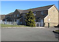
Craig-yr-Hendre, Bedlinog
Viewed across George Street in February 2019. Managed by Hafod Housing Association,
Craig-yr-Hendre is retirement housing containing 20 flats built in 1990.
Image: © Jaggery
Taken: 25 Feb 2019
0.00 miles
2

Six lockup garages, George Street, Bedlinog
Near the corner of Lewis Street.
Image: © Jaggery
Taken: 25 Feb 2019
0.02 miles
3
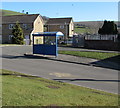
Bedlinog terminus of bus route 79 from Merthyr Tydfil
The blue shelter is alongside George Street at the Bedlinog terminus of bus route 79 from/to Merthyr Tydfil bus station. In February 2019 Route 79 is operated by Stagecoach.
Image: © Jaggery
Taken: 25 Feb 2019
0.03 miles
4

Row of houses, George Street, Bedlinog
On the ascent towards Lewis Street.
Image: © Jaggery
Taken: 25 Feb 2019
0.05 miles
5
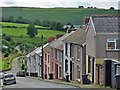
Shadow on Mount Pleasant, Bedlinog
Dead-end street on the east side of Upper High Street.
Image: © Jaggery
Taken: 25 Feb 2019
0.05 miles
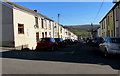
6
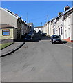
Terraced houses on a steep hill, Bedlinog
Lewis Street.
Image: © Robin Drayton
Taken: 12 Jul 2012
0.05 miles
7
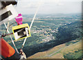
Bedlinog town from above Craig Penddeugae
Aerial Photograph taken from a hangglider looking down on my house in the village of Bedlinog (note this picture was taken in 1992 prior to the demolition of Taff Merthyr Colliery that can be just seen down the valley from Bedlinog)
Image: © nantcoly
Taken: Unknown
0.06 miles
8
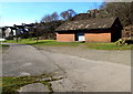
Brick building in a recreation area north of George Street, Bedlinog
A football pitch is about 250 metres behind the camera, so perhaps this building is used as changing rooms.
Image: © Jaggery
Taken: 25 Feb 2019
0.07 miles
9
Steep ascent, Lewis Street, Bedlinog
Lewis Street ascends from George Street towards Upper High Street and Pleasant View.
Image: © Jaggery
Taken: 25 Feb 2019
0.07 miles
10
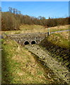
Dry stream bed in Bedlinog
No water is visible in this view of the brook/stream Nant Llwynog on February 25th 2019 during a period of record-breaking winter warmth. The maximum temperature of 20.6 Celsius (69F) at Trawsgoed, Ceredigion today is the highest air temperature ever measured in Wales in February, and the first time a temperature above 20 degrees Celsius (68F) has been recorded in Wales (and the UK) in winter.
Image: © Jaggery
Taken: 25 Feb 2019
0.08 miles