IMAGES TAKEN NEAR TO
Upper High Street, TREHARRIS, CF46 6RY
Introduction
This page details the photographs taken nearby to Upper High Street, CF46 6RY by members of the Geograph project.
The Geograph project started in 2005 with the aim of publishing, organising and preserving representative images for every square kilometre of Great Britain, Ireland and the Isle of Man.

There are currently over 7.5m images from over14,400 individuals and you can help contribute to the project by visiting https://www.geograph.org.uk
Image Map
Images are licensed for reuse under creativecommons.org/licenses/by-sa/2.0
Notes
- Clicking on the map will re-center to the selected point.
- The higher the marker number, the further away the image location is from the centre of the postcode.
Image Listing (118 Images Found)
Images are licensed for reuse under creativecommons.org/licenses/by-sa/2.0
Image
Details
Distance
1
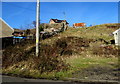
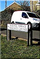
Waste ground in Bedlinog
Viewed from Bedlinog Terrace looking towards Old Quarry Lane.
Image: © Jaggery
Taken: 25 Feb 2019
0.02 miles
2
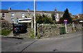
Upper High Street houses, Bedlinog
Between Bedlinog Terrace and Old Quarry Lane.
Image: © Jaggery
Taken: 25 Feb 2019
0.03 miles
3
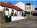
Dark green cabinet, Upper High Street, Bedlinog
Telecoms cabinet viewed in February 2019.
Image: © Jaggery
Taken: 25 Feb 2019
0.03 miles
4
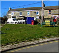
Green bench on a grass triangle, Bedlinog
On the corner of High Street and Upper High Street.
At 280 metres (almost 920 ft) above mean sea level,
this is one of the highest locations in Bedlinog.
Image: © Jaggery
Taken: 25 Feb 2019
0.04 miles
5
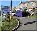
Taff Bargoed Regeneration Programme board in Bedlinog
On the corner of High Street and Upper High Street. The text is also in Welsh.
Image: © Jaggery
Taken: 25 Feb 2019
0.04 miles
6
Bilingual direction sign in Bedlinog
The small black arrow on the sign alongside Upper High Street points
left towards Bedlinog Terrace which is Teras Bedd Llwynog in Welsh.
Image: © Jaggery
Taken: 25 Feb 2019
0.04 miles
7
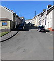
Steep ascent, Lewis Street, Bedlinog
Lewis Street ascends from George Street towards Upper High Street and Pleasant View.
Image: © Jaggery
Taken: 25 Feb 2019
0.04 miles
8
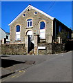
Former Soar chapel, Bedlinog
The Graig Terrace side of the building on the corner of High Street viewed in February 2019.
Soar Methodist Chapel was built in 1889, modified in 1911. The chapel closed in the mid 1990s.
Image: © Jaggery
Taken: 25 Feb 2019
0.06 miles
9
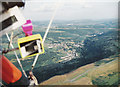
Bedlinog town from above Craig Penddeugae
Aerial Photograph taken from a hangglider looking down on my house in the village of Bedlinog (note this picture was taken in 1992 prior to the demolition of Taff Merthyr Colliery that can be just seen down the valley from Bedlinog)
Image: © nantcoly
Taken: Unknown
0.06 miles
10
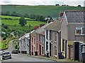
Terraced houses on a steep hill, Bedlinog
Lewis Street.
Image: © Robin Drayton
Taken: 12 Jul 2012
0.06 miles