IMAGES TAKEN NEAR TO
Heol Fawr, TREHARRIS, CF46 6PL
Introduction
This page details the photographs taken nearby to Heol Fawr, CF46 6PL by members of the Geograph project.
The Geograph project started in 2005 with the aim of publishing, organising and preserving representative images for every square kilometre of Great Britain, Ireland and the Isle of Man.

There are currently over 7.5m images from over14,400 individuals and you can help contribute to the project by visiting https://www.geograph.org.uk
Image Map
Images are licensed for reuse under creativecommons.org/licenses/by-sa/2.0
Notes
- Clicking on the map will re-center to the selected point.
- The higher the marker number, the further away the image location is from the centre of the postcode.
Image Listing (6 Images Found)
Images are licensed for reuse under creativecommons.org/licenses/by-sa/2.0
Image
Details
Distance
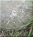
1
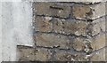
Ordnance Survey Cut Mark
This OS cut mark can be found on the south angle of Penywaun Cottages. It marks a point 244.602m above mean sea level.
Image: © Adrian Dust
Taken: 25 May 2019
0.00 miles
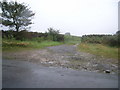
3
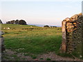
End of dry stone wall in the hills above Nelson
Image: © nick macneill
Taken: 3 Sep 2010
0.09 miles
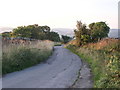
4
Ordnance Survey Rivet
This OS rivet can be found on a stone at the base of the wall NE side of the road. It marks a point 255.285m above mean sea level.
Image: © Adrian Dust
Taken: 25 May 2019
0.13 miles