1
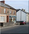
Cosy Corner Nursery, Nelson
Private day nursery located on the corner of Shingrig Road and Donald Street.
Image: © Jaggery
Taken: 17 Mar 2011
0.04 miles
2
Nelson RFC clubhouse
The clubhouse is located at the eastern edge of the club's ground, The Parc, which is set back from Shingrig Road. Nelson Rugby Football Club was founded in 1934. The team's nickname is The Unicorns and a unicorn is prominent in the club's badge, which can be seen on the clubhouse name sign.
Image: © Jaggery
Taken: 17 Mar 2011
0.05 miles
3
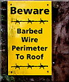
Beware - Barbed Wire Perimeter To Roof, St John the Baptist church, Nelson
The yellow notice is located here. https://www.geograph.org.uk/photo/6003849
Image: © Jaggery
Taken: 17 Dec 2018
0.07 miles
4
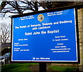
St John the Baptist, High Street, Nelson
Church in Wales church in the Parish of Treharris, Trelewis and Bedlinog with Llanfabon in the Diocese of Llandaff. The church was built in 1887-1889 to designs of architect E.H.Lingen Barker of Hereford. The tower was added in 1904. https://www.geograph.org.uk/photo/6003785 to the blue information board.
Image: © Jaggery
Taken: 17 Dec 2018
0.07 miles
5
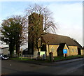
North side of St John the Baptist church, Nelson
This is the Church in Wales church in the Parish of Treharris, Trelewis and Bedlinog with Llanfabon in the Diocese of Llandaff. The church was built in 1887-1889 to the designs of architect E.H.Lingen Barker of Hereford. The tower was added in 1904. https://www.geograph.org.uk/photo/6003840 to the south side of the church. The barbed wire roof perimeter is designed to deter would-be lead thieves.
Image: © Jaggery
Taken: 17 Dec 2018
0.07 miles
6
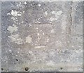
Ordnance Survey Cut Mark
This OS cut mark can be found on the west face of St John's Church. It marks a point 156.917m above mean sea level.
Image: © Adrian Dust
Taken: 25 May 2019
0.07 miles
7
Church of St John the Baptist, Nelson
Image: © John Lord
Taken: 29 Sep 2015
0.08 miles
8
High Street side of St John the Baptist church, Nelson
The south side of the Church in Wales church in the Parish of Treharris, Trelewis and Bedlinog with Llanfabon in the Diocese of Llandaff. The church was built in 1887-1889 to the designs of architect E.H.Lingen Barker of Hereford. The tower was added in 1904.
Image: © Jaggery
Taken: 17 Dec 2018
0.08 miles
9
Saint John's Food Co-op banner, Nelson
The banner on display in December 2018 in St John's churchyard states that
the Food Co-op is in the church hall on Thursdays from 11:30am to 1:30pm.
Image: © Jaggery
Taken: 17 Dec 2018
0.08 miles
10
Information board for St John the Baptist, High Street, Nelson
In December 2018 the board located here https://www.geograph.org.uk/photo/6003776 shows that Sung Eucharist begins at 9am on Sundays. Holy Eucharist begins at 10:30am on Thursdays. All are welcome.
Image: © Jaggery
Taken: 17 Dec 2018
0.08 miles


