IMAGES TAKEN NEAR TO
Clos Cae Pwll, TREHARRIS, CF46 6LA
Introduction
This page details the photographs taken nearby to Clos Cae Pwll, CF46 6LA by members of the Geograph project.
The Geograph project started in 2005 with the aim of publishing, organising and preserving representative images for every square kilometre of Great Britain, Ireland and the Isle of Man.

There are currently over 7.5m images from over14,400 individuals and you can help contribute to the project by visiting https://www.geograph.org.uk
Image Map
Images are licensed for reuse under creativecommons.org/licenses/by-sa/2.0
Notes
- Clicking on the map will re-center to the selected point.
- The higher the marker number, the further away the image location is from the centre of the postcode.
Image Listing (67 Images Found)
Images are licensed for reuse under creativecommons.org/licenses/by-sa/2.0
Image
Details
Distance
1
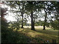
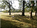
Sunlight and shadow; sheep, trees and pasture
Image: © John Lord
Taken: 29 Sep 2015
0.08 miles
2
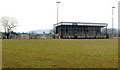
Nelson RFC grandstand
The grandstand is located on the opposite side of the pitch to the clubhouse. http://www.geograph.org.uk/photo/2356560
Image: © Jaggery
Taken: 17 Mar 2011
0.12 miles
3
Ynys Las, Nelson
From the north side of High Street, Ynys Las leads to Maes-yr-onen.
Image: © Jaggery
Taken: 20 Dec 2018
0.14 miles
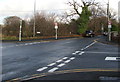
5
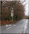
Give way to oncoming vehicles, Bwl Road, Nelson
Vehicles should stop behind the broken white lines if a vehicle is approaching.
The sign text is in English and Welsh.
Image: © Jaggery
Taken: 20 Dec 2018
0.15 miles
6
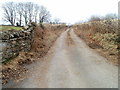
Track to Maesmafon Farm near Nelson
Viewed from Pentwyn Road, just west of the edge of residential Nelson.
Image: © Jaggery
Taken: 17 Mar 2011
0.16 miles
7
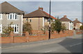
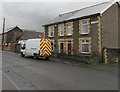
Houses at the western edge of High Street Nelson
Viewed from the edge of the Bwl Road / Pentwyn Road / Llwyncelyn Terrace crossroads.
Image: © Jaggery
Taken: 17 Mar 2011
0.16 miles
8
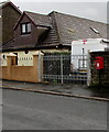
Queen Elizabeth II postbox at the western end of High Street, Nelson
Image: © Jaggery
Taken: 20 Dec 2018
0.17 miles
9
Houses at the western end of High Street, Nelson
High Street leads to Commercial Street about 750 metres ahead.
Image: © Jaggery
Taken: 20 Dec 2018
0.17 miles
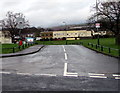
10
Nelson crossroads
The crossroads of Llwyncelyn Terrace (camera side), High Street (on the right),
Pentwyn Road (on the left) and Bwl Road (ahead) at the western edge of Nelson.
Image: © Jaggery
Taken: 22 Dec 2018
0.17 miles