1
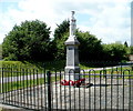
Relocated Trelewis War Memorial
The War Memorial was officially unveiled on Captains Hill on May 31st 1925 as a memorial to the 45 men of Trelewis who died in the Great War. Its original location had by 1999 become isolated, because of mine closures and reshaping of the landscape. It was also suffering some vandalism and beginning to look unkempt and neglected. Thus in 2002, after 3 years of fund-raising by volunteers, a team of Royal Monmouthshire Engineers moved the statue to its new location here, set above the west side of the B4255 near the Ffaldcaiach Inn. http://www.geograph.org.uk/photo/3160746 The rededication of the War Memorial was on June 23rd 2002, after a march of war veterans through the village.
Image: © Jaggery
Taken: 24 May 2011
0.03 miles
2
Ffaldcaiach Inn, Trelewis
Image: © John Lord
Taken: 17 Jul 2010
0.03 miles
3
Ordnance Survey Cut Mark
This OS cut mark can be found on the north buttress of the Railway Bridge. It marks a point 142.387m above mean sea level.
Image: © Adrian Dust
Taken: 1 Feb 2021
0.03 miles
4
Trelewis T-junction
Viewed from this http://www.geograph.org.uk/photo/3220811 footbridge.
Glyn Bargoed Road (B4254) reaches the B4255. Turn left for Bedlinog or right for Nelson and Gelligaer.
Image: © Jaggery
Taken: 24 May 2011
0.04 miles
5
Across Glyn Bargoed Road footbridge, Trelewis
The footbridge http://www.geograph.org.uk/photo/3220825 crosses over Glyn Bargoed Road (B4254) a few metres from the B4255 junction.
Trelewis War Memorial http://www.geograph.org.uk/photo/3220797 is in the background, beyond the footbridge.
Image: © Jaggery
Taken: 24 May 2011
0.05 miles
6
Glyn Bargoed Road footbridge, Trelewis
Viewed from the B4255. Glyn Bargoed Road (B4254) passes under the footbridge.
Image: © Jaggery
Taken: 24 May 2011
0.05 miles
7
War memorial, Trelewis
The picture at
Image describes how this memorial was moved and rededicated
Image: © David Smith
Taken: 27 Sep 2021
0.05 miles
8
Disused railway bridge
The old railway line is now a cycle track.
Image: © Alan Hughes
Taken: 31 Jul 2020
0.05 miles
9
Ffaldcaiach Inn, Trelewis
The inn takes its name from a former animal pound near a stream.
Ffald is Welsh for fold in the sense of an enclosure for livestock.
Nant Caiach or Caeach is the name of a nearby stream.
Image: © Jaggery
Taken: 24 May 2011
0.05 miles
10
Track north of a sports area near Trelewis Community Centre
Viewed from a kissing gate http://www.geograph.org.uk/photo/3160654 at the northern edge of the community centre site.
Image: © Jaggery
Taken: 24 May 2011
0.06 miles


