IMAGES TAKEN NEAR TO
Field Street, TREHARRIS, CF46 6AW
Introduction
This page details the photographs taken nearby to Field Street, CF46 6AW by members of the Geograph project.
The Geograph project started in 2005 with the aim of publishing, organising and preserving representative images for every square kilometre of Great Britain, Ireland and the Isle of Man.

There are currently over 7.5m images from over14,400 individuals and you can help contribute to the project by visiting https://www.geograph.org.uk
Image Map
Images are licensed for reuse under creativecommons.org/licenses/by-sa/2.0
Notes
- Clicking on the map will re-center to the selected point.
- The higher the marker number, the further away the image location is from the centre of the postcode.
Image Listing (49 Images Found)
Images are licensed for reuse under creativecommons.org/licenses/by-sa/2.0
Image
Details
Distance
1
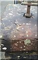
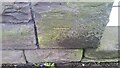
Ordnance Survey Cut Mark
This OS cut mark can be found on the wall at the rear of No29 Field Street. It marks a point 157.911m above mean sea level.
Image: © Adrian Dust
Taken: 1 Feb 2021
0.03 miles
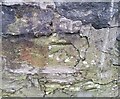
2
Ordnance Survey Cut Mark
This OS cut mark can be found on the south parapet of the Railway Bridge. It marks a point 169.816m above mean sea level.
Image: © Adrian Dust
Taken: 1 Feb 2021
0.05 miles
3
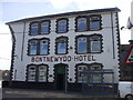
Treharris Kingdom Hall of Jehovah's Witnesses
Image: © Peter Gwenlan
Taken: 27 Jun 2010
0.07 miles
4
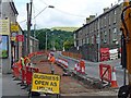
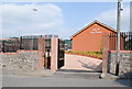
High Street, Trelewis
Regeneration of the High Street courtesy of the European Regional Development Fund.
Image: © Robin Drayton
Taken: 19 Jul 2012
0.08 miles
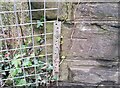
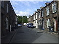
6
Ordnance Survey Rivet
This OS rivet can be found on the wall at the junction of Cherry Tree Way. It marks a point 163.600m above mean sea level.
Image: © Adrian Dust
Taken: 1 Feb 2021
0.13 miles
8
Ordnance Survey Cut Mark
This OS cut mark can be found on No19 High Street. It marks a point 152.476m above mean sea level.
Image: © Adrian Dust
Taken: 1 Feb 2021
0.14 miles
9
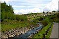
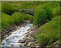
Taff Bargoed river Looking North
Taff Bargoed river Looking North with Garden Village (Stormtown) in the background.
Image: © Wally Haines
Taken: 1 May 2009
0.15 miles