1
Rocky outcrop near Edwardsville
Viewed across the A4054 near the northern boundary of Edwardsville.
Image: © Jaggery
Taken: 27 Mar 2014
0.02 miles
2
Open space and a bench in Edwardsville
Alongside the A4054 at the northern edge of Edwardsville.
Image: © Jaggery
Taken: 27 Mar 2014
0.03 miles
3
Northern boundary of Edwardsville
The A4054 from Merthyr Vale passes the boundary sign for Edwardsville near Treharris.
Image: © Jaggery
Taken: 27 Mar 2014
0.03 miles
4
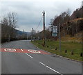
Two speed limit increases on the A4054, Edwardsville
The 20mph speed limit near Edwardsville Primary School http://www.geograph.org.uk/photo/4044760 increases to 30mph and then to the National Speed Limit a short distance further ahead, at the Edwardsville boundary sign. http://www.geograph.org.uk/photo/4045043
Image: © Jaggery
Taken: 27 Mar 2014
0.04 miles
5
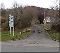
Boulder barrier in Edwardsville
Boulders block vehicular access from the A4054 Cardiff to the road leading to the site of the former Edwardsville Swimming Pool.
Image: © Jaggery
Taken: 27 Mar 2014
0.05 miles
6
Treharne Park, Edwardsville
Treharne Park is a cul-de-sac on the north side of the A4054 Cardiff Road, opposite Treharne Terrace.
Image: © Jaggery
Taken: 27 Mar 2014
0.05 miles
7
Manor Court houses, Edwardsville
Manor Court is at the western end of Taff Vale.
Image: © Jaggery
Taken: 27 Mar 2014
0.05 miles
8
Ordnance Survey Cut Mark
This OS cut mark can be found on the wall NE side of Cardiff Road. It marks a point 153.675m above mean sea level.
Image: © Adrian Dust
Taken: 14 Apr 2018
0.05 miles
9
Western end of the roadway, Tyn-y-Banwen Road, Edwardsville
Beyond the end of the road, a footpath leads to the backs of houses.
Image: © Jaggery
Taken: 27 Mar 2014
0.09 miles
10
Corner of Taff Vale and Manor Court, Edwardsville
Looking towards Manor Court from Taff Vale.
Image: © Jaggery
Taken: 27 Mar 2014
0.09 miles


