IMAGES TAKEN NEAR TO
Nant-Ddu Terrace, TREHARRIS, CF46 5NL
Introduction
This page details the photographs taken nearby to Nant-Ddu Terrace, CF46 5NL by members of the Geograph project.
The Geograph project started in 2005 with the aim of publishing, organising and preserving representative images for every square kilometre of Great Britain, Ireland and the Isle of Man.

There are currently over 7.5m images from over14,400 individuals and you can help contribute to the project by visiting https://www.geograph.org.uk
Image Map
Images are licensed for reuse under creativecommons.org/licenses/by-sa/2.0
Notes
- Clicking on the map will re-center to the selected point.
- The higher the marker number, the further away the image location is from the centre of the postcode.
Image Listing (119 Images Found)
Images are licensed for reuse under creativecommons.org/licenses/by-sa/2.0
Image
Details
Distance
1
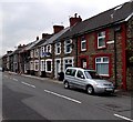
Nant Ddu houses in Edwardsville
Nant Ddu is a row of houses on the north side of the A4054 Cardiff Road.
Image: © Jaggery
Taken: 27 Mar 2014
0.01 miles
3
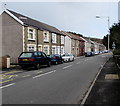
Cardiff Road houses, Edwardsville
The houses are opposite Beechgrove Cemetery.
Image: © Jaggery
Taken: 30 Jan 2016
0.03 miles
4
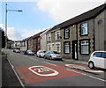
20 on Cardiff Road, Edwardsville
20mph speed limit on the approach to Edwardsville Primary School.
Image: © Jaggery
Taken: 30 Jan 2016
0.03 miles
5
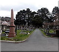
Path through Beechgrove Cemetery, Edwardsville
Viewed from near the cemetery chapel. http://www.geograph.org.uk/photo/3912086
Image: © Jaggery
Taken: 27 Mar 2014
0.03 miles
6
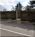
Side entrance to Beechgrove Cemetery, Edwardsville
From Cardiff Road. The gate gives access to the northeast side of the cemetery.
Image: © Jaggery
Taken: 30 Jan 2016
0.03 miles
7
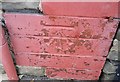
Ordnance Survey Cut Mark
This OS cut mark can be found on No19 Nant Ddu Terrace. It marks a point 148.541m above mean sea level.
Image: © Adrian Dust
Taken: 14 Apr 2018
0.03 miles
8

Rock View Edwardsville
A separately-named and numbered part of Cardiff Road.
Image: © Jaggery
Taken: 27 Mar 2014
0.03 miles
9
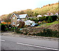
Blackbrook House, Edwardsville
House set back from Cardiff Road near the edge of Nant-Ddu terrace.
The English Blackbrook and the Welsh Nant-Ddu are equivalents.
Image: © Jaggery
Taken: 30 Jan 2016
0.04 miles
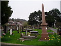
10
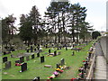
Beechgrove Cemetery, Edwardsville
Municipal cemetery on the south side of the A4054 Cardiff Road.
The English word cemetery is derived from the Greek word for sleeping place.
Image: © Jaggery
Taken: 30 Jan 2016
0.04 miles