1
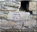
Ordnance Survey Cut Mark
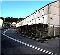
This OS cut mark can be found on the wall NE side of Mary Street. It marks a point 146.344m above mean sea level.
Image: © Adrian Dust
Taken: 14 Apr 2018
0.03 miles
2
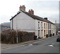
Commercial Terrace houses, Treharris
A row of five houses on the south side of Commercial Terrace.
Image: © Jaggery
Taken: 17 Mar 2011
0.04 miles
3
Masonry remains of a railway bridge in Treharris
Viewed across the A4054 Cardiff Road from Gresham Place.
Old maps show that this was part of the railway route between Quakers Yard High Level station and Treharris station. The route closed in 1964 and both stations have gone. In 2016, Quakers Yard station http://www.geograph.org.uk/photo/3904668 is a smaller version of the original Quakers Yard Low Level station.
Image: © Jaggery
Taken: 30 Jan 2016
0.04 miles
4
Masonry remains of a railway bridge in Treharris
Viewed across the A4054 Cardiff Road near Susannah Place. Old maps show that this was part of the railway route between Quakers Yard High Level station and Treharris station. The route closed in 1964 and both stations have gone. The present-day Quakers Yard station http://www.geograph.org.uk/photo/3904668 is a smaller version of the original Quakers Yard Low Level station.
Image: © Jaggery
Taken: 27 Mar 2014
0.05 miles
5
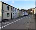
West side of Susannah Place, Treharris
Susannah Place is a separately named and numbered part of the A4054
Cardiff Road, between Windsor Place (behind the camera) and Gresham Place.
Double white lines in the middle of the road indicate no overtaking.
Image: © Jaggery
Taken: 30 Jan 2016
0.05 miles
6
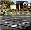
White arrows and blue bus shelter, Treharris
Viewed across the A4054 Cardiff Road.
Image: © Jaggery
Taken: 30 Jan 2016
0.05 miles
7
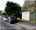
Gresham Place electricity substation, Treharris
Located on the right here. http://www.geograph.org.uk/photo/3915086
The Western Power Distribution electricity substation identifier is GRESHAM PLACE S/S 551862.
Image: © Jaggery
Taken: 30 Jan 2016
0.06 miles
8
Susannah Place, Treharris
Susannah Place is a separately named and numbered part of the A4054 Cardiff Road,
between Gresham Place behind the camera and Windsor Place out of shot ahead.
Image: © Jaggery
Taken: 30 Jan 2016
0.06 miles
9
Bend in the A4054, Treharris
Viewed from opposite the Windsor Place junction. http://www.geograph.org.uk/photo/4889757
Double white lines in the middle of the road indicate no overtaking.
The houses are part of Susannah Place.
Image: © Jaggery
Taken: 30 Jan 2016
0.06 miles
10
Susannah Place, Treharris
Susannah Place is a separately named and numbered part of Cardiff Road.
The Gresham Place turning is on the right.
Image: © Jaggery
Taken: 27 Mar 2014
0.07 miles


