IMAGES TAKEN NEAR TO
The Ferns, TREHARRIS, CF46 5LQ
Introduction
This page details the photographs taken nearby to The Ferns, CF46 5LQ by members of the Geograph project.
The Geograph project started in 2005 with the aim of publishing, organising and preserving representative images for every square kilometre of Great Britain, Ireland and the Isle of Man.

There are currently over 7.5m images from over14,400 individuals and you can help contribute to the project by visiting https://www.geograph.org.uk
Image Map
Images are licensed for reuse under creativecommons.org/licenses/by-sa/2.0
Notes
- Clicking on the map will re-center to the selected point.
- The higher the marker number, the further away the image location is from the centre of the postcode.
Image Listing (5 Images Found)
Images are licensed for reuse under creativecommons.org/licenses/by-sa/2.0
Image
Details
Distance
1
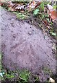
Ordnance Survey Rivet
This OS rivet can be found on the NW side of the path. It marks a point 126.279 above mean sea level.
Image: © Adrian Dust
Taken: 1 Feb 2021
0.16 miles
2
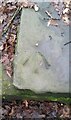
Ordnance Survey Rivet
This OS rivet can be found on the stone stile remains. It marks a point 148.297m above mean sea level.
Image: © Adrian Dust
Taken: 1 Feb 2021
0.17 miles
3
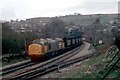
Coal from Deep Navigation
A reminder of how the South Wales Valleys once looked.
This view has changed since the photo was taken some twenty years ago! Coal loaded at Deep Navigation colliery waits to head down the valley to Aberthaw.
No hurry today as the Barry train crew will hang about trying to make overtime!
The view is a rather changed now as the railway track is gone. So have the mines and the winding gear seen behind the train. Of course the many jobs have gone as well both in the mines and the railway. There are no train crews based at Barry to move coal any more and no miners working at Deep Navigation. Both the railway and the mines have been privatised since this picture was taken.
Image: © roger geach
Taken: 9 Apr 1987
0.20 miles
4
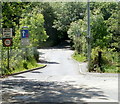
Eastern end of Mill Street, Trelewis
Viewed from the B4254 Glyn Bargoed Road which becomes the B4254 Cardiff Road here.
A sign shows a (relatively) weak bridge ahead (33 tonnes weight limit) on Mill Street.
Image: © Jaggery
Taken: 24 May 2011
0.23 miles
5
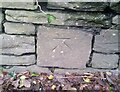
Ordnance Survey Cut Mark
This OS cut mark can be found on the north side of the road. It marks a point 129.756m above mean sea level.
Image: © Adrian Dust
Taken: 1 Feb 2021
0.24 miles