IMAGES TAKEN NEAR TO
Claremont Drive, TREHARRIS, CF46 5LJ
Introduction
This page details the photographs taken nearby to Claremont Drive, CF46 5LJ by members of the Geograph project.
The Geograph project started in 2005 with the aim of publishing, organising and preserving representative images for every square kilometre of Great Britain, Ireland and the Isle of Man.

There are currently over 7.5m images from over14,400 individuals and you can help contribute to the project by visiting https://www.geograph.org.uk
Image Map (2 Images)


Getting Data...Please wait
Leaflet Map data © OpenStreetMap
Images are licensed for reuse under creativecommons.org/licenses/by-sa/2.0
Notes
- Clicking on the map will re-center to the selected point.
- The higher the marker number, the further away the image location is from the centre of the postcode.
Image Listing (2 Images Found)
Images are licensed for reuse under creativecommons.org/licenses/by-sa/2.0
Image
Details
Distance
1
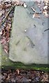
Ordnance Survey Rivet
This OS rivet can be found on the stone stile remains. It marks a point 148.297m above mean sea level.
Image: © Adrian Dust
Taken: 1 Feb 2021
0.15 miles
2
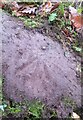
Ordnance Survey Rivet
This OS rivet can be found on the NW side of the path. It marks a point 126.279 above mean sea level.
Image: © Adrian Dust
Taken: 1 Feb 2021
0.19 miles