IMAGES TAKEN NEAR TO
Mary Street, TREHARRIS, CF46 5LH
Introduction
This page details the photographs taken nearby to Mary Street, CF46 5LH by members of the Geograph project.
The Geograph project started in 2005 with the aim of publishing, organising and preserving representative images for every square kilometre of Great Britain, Ireland and the Isle of Man.

There are currently over 7.5m images from over14,400 individuals and you can help contribute to the project by visiting https://www.geograph.org.uk
Image Map
Images are licensed for reuse under creativecommons.org/licenses/by-sa/2.0
Notes
- Clicking on the map will re-center to the selected point.
- The higher the marker number, the further away the image location is from the centre of the postcode.
Image Listing (96 Images Found)
Images are licensed for reuse under creativecommons.org/licenses/by-sa/2.0
Image
Details
Distance
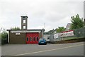
1
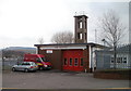
Treharris Fire Station and training tower
Small fire station located on the corner of Thomas Street and Commercial Terrace.
It is part of the South Wales Fire and Rescue Service.
Image: © Jaggery
Taken: 17 Mar 2011
0.01 miles
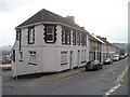
2
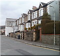
Glenview Villas, Treharris
A short row of houses between Commercial Terrace and John Street. The houses face Treharris Fire Station. http://www.geograph.org.uk/photo/2311749
Image: © Jaggery
Taken: 17 Mar 2011
0.01 miles
3
Treharris Unionist Club
Social club at 19 John Street.
Image: © Jaggery
Taken: 17 Mar 2011
0.06 miles
5
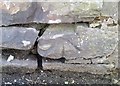
Ordnance Survey Cut Mark
This OS cut mark can be found on the wall south side of Commercial Terrace. It marks a point 158.908m above mean sea level.
Image: © Adrian Dust
Taken: 14 Apr 2018
0.06 miles
6
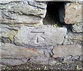
Ordnance Survey Cut Mark
This OS cut mark can be found on the wall NE side of Mary Street. It marks a point 146.344m above mean sea level.
Image: © Adrian Dust
Taken: 14 Apr 2018
0.06 miles
7
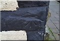
Ordnance Survey Cut Mark
This OS cut mark can be found on No21 Thomas Street. It marks a point 150.879m above mean sea level.
Image: © Adrian Dust
Taken: 14 Apr 2018
0.07 miles
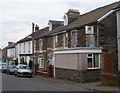
8
Commercial Terrace houses, Treharris
A row of five houses on the south side of Commercial Terrace.
Image: © Jaggery
Taken: 17 Mar 2011
0.07 miles
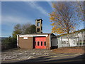
9
Treharris Fire Station
Treharris Fire Station, Thomas Street, Treharris
Image: © Kevin Hale
Taken: 4 Jun 2007
0.07 miles
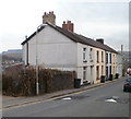
10
Brynteg, Treharris
The long row of houses is on Brynteg, Cardiff Road (B4254). The nearest house is on the corner of the southern section of a road named The Park.
Image: © Jaggery
Taken: 17 Mar 2011
0.07 miles