1
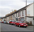
Cardiff Road / Perrott Street Junction, Treharris
Formerly occupied by the Salvation Army (top floor) and previously by a billiards hall and hairdresser (1950s) Pearks (sp) had a groceries store on the ground floor.
Image: © Kev Griffin
Taken: 14 Nov 2004
0.01 miles
2
Deep Navigation Colliery, Treharris, view up Fox Street
This photograph is taken facing up Fox Street from the entrance gate to the Deep Navigation Colliery in Treharris. See
Image This photo was taken during the miners' dispute in 1984.
Image: © Tom Jolliffe
Taken: Unknown
0.03 miles
3
Ordnance Survey Cut Mark
This OS cut mark can be found on the Library, Perrott Street. It marks a point 148.627m above mean sea level.
Image: © Adrian Dust
Taken: 14 Apr 2018
0.08 miles
4
Colliers' Cwtch, Bargoed Terrace, Treharris
The view east along Cardiff Road. The row of houses is named Bargoed Terrace.
Facing the lamppost (second red car) is Colliers' Cwtch club, formerly Treharris Workingmen's Club, also known as the Dog & Rabbit. Cwtch is a dialect word in some parts of Wales, from the Welsh word meaning to cuddle. So the probable shade of meaning here is a snug place.
Image: © Jaggery
Taken: 17 Mar 2011
0.10 miles
5
Colourful houses, Bargoed Terrace, Cardiff Road, Treharris
Viewed from Treharris Bus Station. http://www.geograph.org.uk/photo/2311548
Image: © Jaggery
Taken: 17 Mar 2011
0.10 miles
6
Treharris Bus Station
Treharris Bus Station consists of two bus shelters on the edge of a small semicircular turning area on the north side of Cardiff Road. There are none of the facilities usually found in bigger bus stations.
A Stagecoach bus on route 78 (Pontypridd to Merthyr via Nelson) is waiting to depart for Merthyr Tydfil.
Image: © Jaggery
Taken: 17 Mar 2011
0.10 miles
7
Trelewis Drift Deep Navigation Taff Merthyr Colliery
This is a commemorative stone at the entrance to what was the old mine at Trelewis.
Image: © Nick Mutton 01329 000000
Taken: 23 Sep 2007
0.13 miles
8
Deep Navigation Colliery, Treharris, South Wales
This was, I think, the main entrance to Deep Navigation Colliery in Treharris. At the time this picture was taken, the pit was idle during the prolonged industrial dispute. Many individuals and groups tried to support the local community during the dispute with donations of food and necessities, etc. Looking back, there can be few who do not see the ending of coal production at the pit as anything but a disaster for the whole community.
The pit has now disappeared, and new streets and some housing have been built in its place http://maps.google.co.uk/maps?f=q&source=s_q&hl=en&geocode=&q=trelewis&sll=53.800651,-4.064941&sspn=12.270158,27.070313&ie=UTF8&hq=&hnear=Trelewis,+Treharris,+Mid+Glamorgan,+United+Kingdom&ll=51.666134,-3.302443&spn=0.003168,0.006609&t=h&z=17&layer=c&cbll=51.666067,-3.30257&panoid=fgZvEoaoAbNEfpnj_EPBaw&cbp=12,231.77,,0,5 .
See
Image] and
Image] and
Image] for Chris Allen's pictures of the colliery as it was.
"Deep Navigation Colliery was situated near Treharris in the Taff Bargoed Valley. In 1878 two shafts were sunk at the site which were, at the time, the deepest pits in the south Wales coalfield. During this period the mine was called Harris' Navigation Colliery after the name of the principal shareholder, F.W. Harris. The same man also gave his name to the neighbouring village of Treharris.
In 1893, the Colliery was purchased by the Ocean Coal Co. Ltd. who changed its name to Deep Navigation Colliery. The Colliery produced high quality steam coal which was greatly in demand notably by Cunard Steamlines. Deep Navigation became the sole source of the coal used for the record-breaking trans-Atlantic crossings of both the SS Mauretania and the SS Lusitania. Another important event was the construction of the first ever pit head baths in the south Wales coalfield in 1916.
Upon Nationalisation in 1947, the Colliery was placed into the National Coal Boards South Western Division No. 4 (Aberdare) Area, Group No. 4. Deep Navigation was the subject of heavy investment and reorganisation during the 1960s but remained in production until March 1991."
Source: Ray Lawrence, The South Wales Coalfield Directory, Vol. 2 (1998 edn), p. 191
See http://www.archiveswales.org.uk/anw/get_collection.php?inst_id=35&coll_id=11590&expand=&L=1
Image: © Tom Jolliffe
Taken: Unknown
0.13 miles
9
Ordnance Survey Cut Mark
This OS cut mark can be found on No1 William Terrace. It marks a point 182.078m above mean sea level.
Image: © Adrian Dust
Taken: 14 Apr 2018
0.14 miles
10
Treharris Health Centre
Set back from, and above, Cardiff Road, located between St Matthias church http://www.geograph.org.uk/photo/2311630 and Treharris Bus Station. http://www.geograph.org.uk/photo/2311548
Image: © Jaggery
Taken: 17 Mar 2011
0.16 miles


