IMAGES TAKEN NEAR TO
Navigation Close, TREHARRIS, CF46 5EX
Introduction
This page details the photographs taken nearby to Navigation Close, CF46 5EX by members of the Geograph project.
The Geograph project started in 2005 with the aim of publishing, organising and preserving representative images for every square kilometre of Great Britain, Ireland and the Isle of Man.

There are currently over 7.5m images from over14,400 individuals and you can help contribute to the project by visiting https://www.geograph.org.uk
Image Map
Images are licensed for reuse under creativecommons.org/licenses/by-sa/2.0
Notes
- Clicking on the map will re-center to the selected point.
- The higher the marker number, the further away the image location is from the centre of the postcode.
Image Listing (50 Images Found)
Images are licensed for reuse under creativecommons.org/licenses/by-sa/2.0
Image
Details
Distance
1
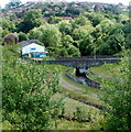
Cardiff Road river bridge, Trelewis
Viewed from Taff Bargoed Millennium Park. A stone bridge carries Cardiff Road
over a man-made channel conveying the Taff Bargoed river.
Image: © Jaggery
Taken: 24 May 2011
0.04 miles
2
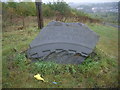
Trelewis Drift Deep Navigation Taff Merthyr Colliery
This is a commemorative stone at the entrance to what was the old mine at Trelewis.
Image: © Nick Mutton 01329 000000
Taken: 23 Sep 2007
0.05 miles
3
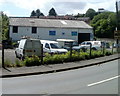
Autocare Service, Trelewis
Tyres, servicing, repairs and MoT test centre, located near a hairpin bend in Cardiff Road (B4255).
Image: © Jaggery
Taken: 24 May 2011
0.06 miles
4
Bridge over the waterway, Trelewis
Image: © Nick Mutton 01329 000000
Taken: 23 Sep 2007
0.06 miles
5
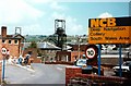
Deep Navigation Colliery, Treharris, South Wales
This was, I think, the main entrance to Deep Navigation Colliery in Treharris. At the time this picture was taken, the pit was idle during the prolonged industrial dispute. Many individuals and groups tried to support the local community during the dispute with donations of food and necessities, etc. Looking back, there can be few who do not see the ending of coal production at the pit as anything but a disaster for the whole community.
The pit has now disappeared, and new streets and some housing have been built in its place http://maps.google.co.uk/maps?f=q&source=s_q&hl=en&geocode=&q=trelewis&sll=53.800651,-4.064941&sspn=12.270158,27.070313&ie=UTF8&hq=&hnear=Trelewis,+Treharris,+Mid+Glamorgan,+United+Kingdom&ll=51.666134,-3.302443&spn=0.003168,0.006609&t=h&z=17&layer=c&cbll=51.666067,-3.30257&panoid=fgZvEoaoAbNEfpnj_EPBaw&cbp=12,231.77,,0,5 .
See Image] and Image] and Image] for Chris Allen's pictures of the colliery as it was.
"Deep Navigation Colliery was situated near Treharris in the Taff Bargoed Valley. In 1878 two shafts were sunk at the site which were, at the time, the deepest pits in the south Wales coalfield. During this period the mine was called Harris' Navigation Colliery after the name of the principal shareholder, F.W. Harris. The same man also gave his name to the neighbouring village of Treharris.
In 1893, the Colliery was purchased by the Ocean Coal Co. Ltd. who changed its name to Deep Navigation Colliery. The Colliery produced high quality steam coal which was greatly in demand notably by Cunard Steamlines. Deep Navigation became the sole source of the coal used for the record-breaking trans-Atlantic crossings of both the SS Mauretania and the SS Lusitania. Another important event was the construction of the first ever pit head baths in the south Wales coalfield in 1916.
Upon Nationalisation in 1947, the Colliery was placed into the National Coal Boards South Western Division No. 4 (Aberdare) Area, Group No. 4. Deep Navigation was the subject of heavy investment and reorganisation during the 1960s but remained in production until March 1991."
Source: Ray Lawrence, The South Wales Coalfield Directory, Vol. 2 (1998 edn), p. 191
See http://www.archiveswales.org.uk/anw/get_collection.php?inst_id=35&coll_id=11590&expand=&L=1
Image: © Tom Jolliffe
Taken: Unknown
0.08 miles
6
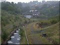
Looking downstream, Trelewis
Image: © Nick Mutton 01329 000000
Taken: 23 Sep 2007
0.08 miles
7
Foot and cycle bridge in Taff Bargoed Park
Image: © David Smith
Taken: 27 Sep 2021
0.09 miles
8
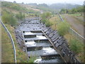
Water coming off the hills - taken from bridge
Image: © Nick Mutton 01329 000000
Taken: 23 Sep 2007
0.09 miles
9
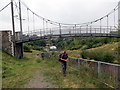
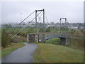
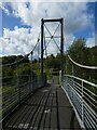
Pont Grog / Suspension Bridge
Cerddwr ger bont grog sy'n rhychwantu Afon Bargod Taf.
Walker near a suspension bridge spanning the Bargod Taff river.
Image: © Alan Richards
Taken: 9 Sep 2012
0.09 miles
10
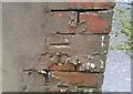
Ordnance Survey Cut Mark
This OS cut mark can be found on The Old Surgery. It marks a point 123.252m above mean sea level.
Image: © Adrian Dust
Taken: 1 Feb 2021
0.09 miles