IMAGES TAKEN NEAR TO
Wingfield Rise, TREHARRIS, CF46 5EN
Introduction
This page details the photographs taken nearby to Wingfield Rise, CF46 5EN by members of the Geograph project.
The Geograph project started in 2005 with the aim of publishing, organising and preserving representative images for every square kilometre of Great Britain, Ireland and the Isle of Man.

There are currently over 7.5m images from over14,400 individuals and you can help contribute to the project by visiting https://www.geograph.org.uk
Image Map
Images are licensed for reuse under creativecommons.org/licenses/by-sa/2.0
Notes
- Clicking on the map will re-center to the selected point.
- The higher the marker number, the further away the image location is from the centre of the postcode.
Image Listing (81 Images Found)
Images are licensed for reuse under creativecommons.org/licenses/by-sa/2.0
Image
Details
Distance
1
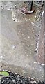
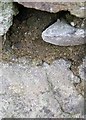
Ordnance Survey Rivet
This OS rivet can be found on the step of No18 Wingfield Terrace. It marks a point 132.756m above mean sea level.
Image: © Adrian Dust
Taken: 7 Oct 2018
0.02 miles
2
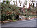
Steps up from Cardiff Road, Quakers Yard
From the south side of the road, near the Glantaff Inn. http://www.geograph.org.uk/photo/4813644
Image: © Jaggery
Taken: 30 Jan 2016
0.11 miles
3
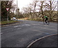
Cycling through Quakers Yard
A cyclist on the A4054 passes the Cardiff Road junction in Quakers Yard.
Image: © Jaggery
Taken: 30 Jan 2016
0.11 miles
4
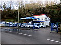
Antrac Motors, Rock Garage, Quakers Yard
New and used light commercial vehicles dealers on the south side of the A4054 Cardiff Road.
Image: © Jaggery
Taken: 30 Jan 2016
0.11 miles
5
Ordnance Survey Rivet
This OS rivet (arrow lost to cement covering) can be found on the stone SE side of Wingfield Terrace. It marks a point 140.790m above mean sea level.
Image: © Adrian Dust
Taken: 7 Oct 2018
0.12 miles
6
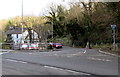
Junction of the A4054 and Cardiff Road, Quakers Yard
Looking across the A4054. The Glantaff Inn http://www.geograph.org.uk/photo/4813644 is on the left.
Image: © Jaggery
Taken: 30 Jan 2016
0.12 miles
7
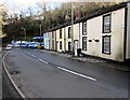
Rock Houses, Cardiff Road, Quakers Yard
Row of houses extending to the edge of Antrac Motors in Rock Garage. https://www.geograph.org.uk/photo/5864146
Image: © Jaggery
Taken: 30 Jan 2016
0.12 miles
8
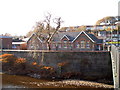
Ysgol Rhyd Y Grug
This school is the Welsh Medium Primary School for the lower Merthyr Valley and is situated at the confluence of the Taff and Taff Bargoed Rivers
Image: © nantcoly
Taken: 29 Nov 2005
0.12 miles
9
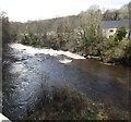
White water on the River Taff, Quakers Yard
From the lower left corner of the photo, the smaller Bargoed Taff flows into the River Taff.
Image: © Jaggery
Taken: 30 Jan 2016
0.13 miles
10
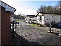
Woodlands Park residential park homes entrance gates, Quakers Yard
At the southern end of Woodlands Crescent, the park homes site is on a bank of the River Taff.
A park home is a detached bungalow-style house, usually in a private estate, as here, located on plots known as pitches. Legally, they are mobile homes and are covered by their own legislation.
Image: © Jaggery
Taken: 30 Jan 2016
0.13 miles