1
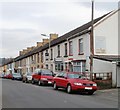
Deep Navigation Colliery, Treharris, view up Fox Street
This photograph is taken facing up Fox Street from the entrance gate to the Deep Navigation Colliery in Treharris. See
Image This photo was taken during the miners' dispute in 1984.
Image: © Tom Jolliffe
Taken: Unknown
0.02 miles
2
Cardiff Road / Perrott Street Junction, Treharris
Formerly occupied by the Salvation Army (top floor) and previously by a billiards hall and hairdresser (1950s) Pearks (sp) had a groceries store on the ground floor.
Image: © Kev Griffin
Taken: 14 Nov 2004
0.03 miles
3
Colliers' Cwtch, Bargoed Terrace, Treharris
The view east along Cardiff Road. The row of houses is named Bargoed Terrace.
Facing the lamppost (second red car) is Colliers' Cwtch club, formerly Treharris Workingmen's Club, also known as the Dog & Rabbit. Cwtch is a dialect word in some parts of Wales, from the Welsh word meaning to cuddle. So the probable shade of meaning here is a snug place.
Image: © Jaggery
Taken: 17 Mar 2011
0.07 miles
4
Colourful houses, Bargoed Terrace, Cardiff Road, Treharris
Viewed from Treharris Bus Station. http://www.geograph.org.uk/photo/2311548
Image: © Jaggery
Taken: 17 Mar 2011
0.07 miles
5
Treharris Bus Station
Treharris Bus Station consists of two bus shelters on the edge of a small semicircular turning area on the north side of Cardiff Road. There are none of the facilities usually found in bigger bus stations.
A Stagecoach bus on route 78 (Pontypridd to Merthyr via Nelson) is waiting to depart for Merthyr Tydfil.
Image: © Jaggery
Taken: 17 Mar 2011
0.07 miles
6
Ordnance Survey Cut Mark
This OS cut mark can be found on the Library, Perrott Street. It marks a point 148.627m above mean sea level.
Image: © Adrian Dust
Taken: 14 Apr 2018
0.07 miles
7
Ordnance Survey Cut Mark
This OS cut mark can be found on No1 William Terrace. It marks a point 182.078m above mean sea level.
Image: © Adrian Dust
Taken: 14 Apr 2018
0.12 miles
8
Treharris Health Centre
Set back from, and above, Cardiff Road, located between St Matthias church http://www.geograph.org.uk/photo/2311630 and Treharris Bus Station. http://www.geograph.org.uk/photo/2311548
Image: © Jaggery
Taken: 17 Mar 2011
0.13 miles
9
St. Matthias' Church, Treharris
Image: © Gareth James
Taken: 21 Oct 2016
0.13 miles
10
St Matthias Church
Parish Church of Treharris.
Image: © Alan Hughes
Taken: 31 Jul 2020
0.13 miles


