1
Ordnance Survey Rivet
This OS rivet (arrow lost to cement covering) can be found on the stone SE side of Wingfield Terrace. It marks a point 140.790m above mean sea level.
Image: © Adrian Dust
Taken: 7 Oct 2018
0.04 miles
2
Ordnance Survey Rivet
This OS rivet can be found on the step of No18 Wingfield Terrace. It marks a point 132.756m above mean sea level.
Image: © Adrian Dust
Taken: 7 Oct 2018
0.06 miles
3
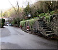
Steps up from Cardiff Road, Quakers Yard
From the south side of the road, near the Glantaff Inn. http://www.geograph.org.uk/photo/4813644
Image: © Jaggery
Taken: 30 Jan 2016
0.11 miles
4
Rickety steps opposite the Glantaff Inn, Quakers Yard
There is nothing to stop anyone using these open-sided steps opposite the Glantaff Inn http://www.geograph.org.uk/photo/4813644
I did not do so. They look structurally unsafe, an impression reinforced by the red barriers alongside the wall.
Image: © Jaggery
Taken: 30 Jan 2016
0.12 miles
5
Junction of the A4054 and Cardiff Road, Quakers Yard
Looking across the A4054. The Glantaff Inn http://www.geograph.org.uk/photo/4813644 is on the left.
Image: © Jaggery
Taken: 30 Jan 2016
0.12 miles
6
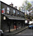
Wooden bench outside the Glantaff Inn, Quakers Yard
The Glantaff Inn is on a bank of the Bargod Taf river. http://www.geograph.org.uk/photo/4813708
Image: © Jaggery
Taken: 30 Jan 2016
0.12 miles
7
Quakers? Yard: post office
This branch will close down at the end of February 2008.
Image: © Chris Downer
Taken: 18 Feb 2008
0.12 miles
8
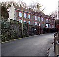
Row of houses, Dan-y-twyn, Quakers Yard
Houses set above road level, accessed up steps.
Image: © Jaggery
Taken: 30 Jan 2016
0.12 miles
9
Cycling through Quakers Yard
A cyclist on the A4054 passes the Cardiff Road junction in Quakers Yard.
Image: © Jaggery
Taken: 30 Jan 2016
0.12 miles
10
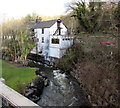
Riverside pub in Quakers Yard
The Glantaff Inn http://www.geograph.org.uk/photo/4813644 is on a bank of the Bargod Taf near its confluence http://www.geograph.org.uk/photo/4813660 with the River Taff.
Image: © Jaggery
Taken: 30 Jan 2016
0.12 miles


