IMAGES TAKEN NEAR TO
Thornwood Place, TREHARRIS, CF46 5AB
Introduction
This page details the photographs taken nearby to Thornwood Place, CF46 5AB by members of the Geograph project.
The Geograph project started in 2005 with the aim of publishing, organising and preserving representative images for every square kilometre of Great Britain, Ireland and the Isle of Man.

There are currently over 7.5m images from over14,400 individuals and you can help contribute to the project by visiting https://www.geograph.org.uk
Image Map
Images are licensed for reuse under creativecommons.org/licenses/by-sa/2.0
Notes
- Clicking on the map will re-center to the selected point.
- The higher the marker number, the further away the image location is from the centre of the postcode.
Image Listing (109 Images Found)
Images are licensed for reuse under creativecommons.org/licenses/by-sa/2.0
Image
Details
Distance
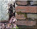
2
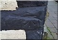
Ordnance Survey Cut Mark
This OS cut mark can be found on No21 Thomas Street. It marks a point 150.879m above mean sea level.
Image: © Adrian Dust
Taken: 14 Apr 2018
0.08 miles
3
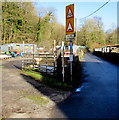
Warning signs, Mill Street, Quakers Yard
Warning of a hump (twmpath in Welsh) in the road ahead, and cyclists.
Mill Street is part of National Cycle Network Route 47, a mainly inland route through south and west Wales.
Its most easterly point is in the city of Newport. Its most westerly point is in Fishguard.
Image: © Jaggery
Taken: 30 Jan 2016
0.11 miles
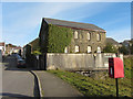
4
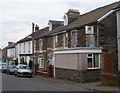
Treharris Unionist Club
Social club at 19 John Street.
Image: © Jaggery
Taken: 17 Mar 2011
0.11 miles
5
Ordnance Survey Cut Mark
This OS cut mark can be found on the wall SE side of the path. It marks a point 113.489m above mean sea level.
Image: © Adrian Dust
Taken: 14 Apr 2018
0.12 miles
6
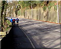
Jogging up from Quakers Yard
Three male joggers ascend the A4054 Cardiff Road pavement from Quakers Yard towards Treharris.
Image: © Jaggery
Taken: 30 Jan 2016
0.12 miles
7
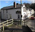
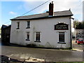
Quakers Yard Inn, Quakers Yard
On the corner of Dan-y-twyn and Mill Street. This is one of the oldest buildings in Quakers Yard.
One source states that it had "opened by the late 18th century".
Image: © Jaggery
Taken: 30 Jan 2016
0.12 miles
8
West side of the Quakers Yard Inn, Quakers Yard
Mill Street side of the inn on the corner of Dan-y-twyn.
This is one of the oldest buildings in Quakers Yard.
One source states that it had "opened by the late 18th century".
Image: © Jaggery
Taken: 30 Jan 2016
0.12 miles
9
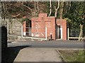
Quakers? Yard: gents? toilet
This most basic of toilet facilities, a steel trough-like urinal is against the back of the central wall, accessible from either entrance. It is open-air and has no facilities for hand washing and there is no equivalent for ladies, as far as I could see. It is made from the finest red sandstone and the design and materials were replicated in other parts of the village.
Image: © Chris Downer
Taken: 18 Feb 2008
0.13 miles