IMAGES TAKEN NEAR TO
Greenfield Terrace, MOUNTAIN ASH, CF45 4SW
Introduction
This page details the photographs taken nearby to Greenfield Terrace, CF45 4SW by members of the Geograph project.
The Geograph project started in 2005 with the aim of publishing, organising and preserving representative images for every square kilometre of Great Britain, Ireland and the Isle of Man.

There are currently over 7.5m images from over14,400 individuals and you can help contribute to the project by visiting https://www.geograph.org.uk
Image Map
Images are licensed for reuse under creativecommons.org/licenses/by-sa/2.0
Notes
- Clicking on the map will re-center to the selected point.
- The higher the marker number, the further away the image location is from the centre of the postcode.
Image Listing (69 Images Found)
Images are licensed for reuse under creativecommons.org/licenses/by-sa/2.0
Image
Details
Distance
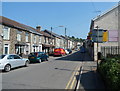
1
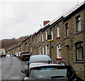
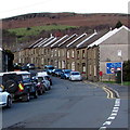
Greenfield Terrace houses, Abercynon
Greenfield Terrace leads to a primary school named Ysgol Gynradd Gymraeg.
Image: © Jaggery
Taken: 6 Feb 2019
0.01 miles
2
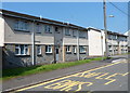
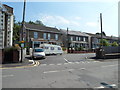
Abertaf Farm Flats, Abercynon
Viewed across Greenfield Terrace. There are 14 flats in Abertaf Farm Flats, eight in view and six set back along a side road between these two buildings.
Image: © Jaggery
Taken: 10 Aug 2012
0.01 miles
3
Restrictions ahead, Greenfield Terrace, Abercynon
A large blue sign at the southern end of Greenfield Terrace shows
a 7.5 tonne weight restriction and an 8' 6" width restriction 510 yards ahead.
Image: © Jaggery
Taken: 10 Aug 2012
0.01 miles
4
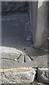
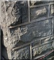
Ordnance Survey Pivot
This OS pivot can be found on the step of No11 Greenfield Terrace. It marks a point 102.053m above mean sea level.
Image: © Adrian Dust
Taken: 7 Oct 2018
0.02 miles
5
Greenfield Terrace, Abercynon
A sign on the right http://www.geograph.org.uk/photo/3079414 shows weight and width limits ahead.
Image: © Jaggery
Taken: 30 Jan 2016
0.03 miles
6
Western end of Fife Street, Abercynon
Viewed across Greenfield Terrace.
Image: © Jaggery
Taken: 10 Aug 2012
0.04 miles
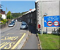
7
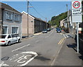
20mph school zone, Abercynon
The 30mph speed limit on Greenfield Terrace reduces to 20mph on the approach to Abercynon Community Primary School. http://www.geograph.org.uk/photo/3079455
Image: © Jaggery
Taken: 10 Aug 2012
0.04 miles
8
Ordnance Survey Cut Mark
This OS cut mark can be found on No1 Birchgrove Villas. It marks a point 98.649m above mean sea level.
Image: © Adrian Dust
Taken: 7 Oct 2018
0.05 miles
9
Glancynon Terrace, Abercynon
Glancynon Terrace heads away from the central area of Abercynon, past Glancynon Stores on the right.
Image: © Jaggery
Taken: 10 Aug 2012
0.06 miles
10
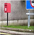
Queen Elizabeth II postbox, Greenfield Terrace, Abercynon
Located here. https://www.geograph.org.uk/photo/3079414
Image: © Jaggery
Taken: 6 Feb 2019
0.06 miles