1
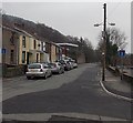
Cardiff Road houses in Mountain Ash
Houses at the SE end of Cardiff Road, viewed from a small (free) car park on a bank of the Afon Cynon.
Image: © Jaggery
Taken: 30 Jan 2014
0.06 miles
2
The Cresselly Arms, Mountain Ash
A large skip was alongside the pub at 31 Cardiff Road at the late January 2014 date of this view.
Image: © Jaggery
Taken: 30 Jan 2014
0.07 miles
3
Blocked-off SE end of Cardiff Road, Mountain Ash
Viewed from opposite the Cresselly Arms. http://www.geograph.org.uk/photo/3830435
About 100 metres ahead, black posts block the passage of any vehicle wider than a motorbike.
Image: © Jaggery
Taken: 30 Jan 2014
0.07 miles
4
Public artwork near Riverside Park, Mountain Ash
This is a rather unsettling example of public artwork on both sides of the Afon Cynon. In view are many grotesque human masks on top of a wall, and one embedded in the wall partway down. In the absence of any explanatory signs, I asked the sole passer-by if he knew what is being depicted. He shrugged, saying he was a visitor to this area, just like me...
Image: © Jaggery
Taken: 30 Jan 2014
0.08 miles
5
Junction of Cardiff Road and Troed-y-rhiw Road, Mountain Ash
Cardiff Road is on the left.
Image: © Jaggery
Taken: 30 Jan 2014
0.08 miles
6
Downstream along the Afon Cynon, Mountain Ash
Looking SE from this http://www.geograph.org.uk/photo/4093042 bridge. The Cynon is a major tributary
of the River Taff, into which it flows at Abercynon.
Image: © Jaggery
Taken: 30 Jan 2014
0.08 miles
7
Bridge over the Afon Cynon, Mountain Ash
View from the Cardiff Road (north) side. The bridge gives access to a path to the northern entrance http://www.geograph.org.uk/photo/4092775 to Mountain Ash railway station. This route is a combined footpath and cycleway, part of National Cycle Network route 478.
Image: © Jaggery
Taken: 30 Jan 2014
0.09 miles
8
Upstream along the Afon Cynon, Mountain Ash
Here about 12 metres (c40ft) wide, the Cynon flows towards this http://www.geograph.org.uk/photo/4093042 bridge.
Image: © Jaggery
Taken: 30 Jan 2014
0.12 miles
9
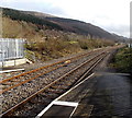
SE from Mountain Ash railway station
The next station ahead is Penrhiwceiber, nearly a mile (c1.6km) ahead.
This is the Aberdare branch of the Merthyr Line.
Image: © Jaggery
Taken: 25 Jan 2014
0.13 miles
10
Riverside path in Mountain Ash
The path is along the south bank of the Afon Cynon.
Image: © Jaggery
Taken: 25 Jan 2014
0.13 miles


