IMAGES TAKEN NEAR TO
Cwrt Abergorci, MOUNTAIN ASH, CF45 4FG
Introduction
This page details the photographs taken nearby to Cwrt Abergorci, CF45 4FG by members of the Geograph project.
The Geograph project started in 2005 with the aim of publishing, organising and preserving representative images for every square kilometre of Great Britain, Ireland and the Isle of Man.

There are currently over 7.5m images from over14,400 individuals and you can help contribute to the project by visiting https://www.geograph.org.uk
Image Map
Images are licensed for reuse under creativecommons.org/licenses/by-sa/2.0
Notes
- Clicking on the map will re-center to the selected point.
- The higher the marker number, the further away the image location is from the centre of the postcode.
Image Listing (73 Images Found)
Images are licensed for reuse under creativecommons.org/licenses/by-sa/2.0
Image
Details
Distance
1
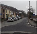
Blocked-off SE end of Cardiff Road, Mountain Ash
Viewed from opposite the Cresselly Arms. http://www.geograph.org.uk/photo/3830435
About 100 metres ahead, black posts block the passage of any vehicle wider than a motorbike.
Image: © Jaggery
Taken: 30 Jan 2014
0.02 miles
2
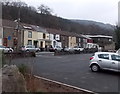
Cardiff Road houses in Mountain Ash
Houses at the SE end of Cardiff Road, viewed from a small (free) car park on a bank of the Afon Cynon.
Image: © Jaggery
Taken: 30 Jan 2014
0.04 miles
3
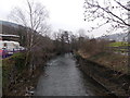
Downstream along the Afon Cynon, Mountain Ash
Looking SE from this http://www.geograph.org.uk/photo/4093042 bridge. The Cynon is a major tributary
of the River Taff, into which it flows at Abercynon.
Image: © Jaggery
Taken: 30 Jan 2014
0.05 miles
5
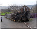
Public artwork near Riverside Park, Mountain Ash
This is a rather unsettling example of public artwork on both sides of the Afon Cynon. In view are many grotesque human masks on top of a wall, and one embedded in the wall partway down. In the absence of any explanatory signs, I asked the sole passer-by if he knew what is being depicted. He shrugged, saying he was a visitor to this area, just like me...
Image: © Jaggery
Taken: 30 Jan 2014
0.08 miles
6
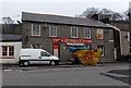
The Cresselly Arms, Mountain Ash
A large skip was alongside the pub at 31 Cardiff Road at the late January 2014 date of this view.
Image: © Jaggery
Taken: 30 Jan 2014
0.08 miles
7
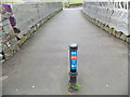
Bridge over the Afon Cynon, Mountain Ash
View from the Cardiff Road (north) side. The bridge gives access to a path to the northern entrance http://www.geograph.org.uk/photo/4092775 to Mountain Ash railway station. This route is a combined footpath and cycleway, part of National Cycle Network route 478.
Image: © Jaggery
Taken: 30 Jan 2014
0.08 miles
8
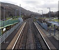
View SE from the station footbridge at Mountain Ash
Looking along the Aberdare branch of the Merthyr Line towards Penrhiwceiber station.
Image: © Jaggery
Taken: 25 Jan 2014
0.09 miles
9
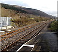
SE from Mountain Ash railway station
The next station ahead is Penrhiwceiber, nearly a mile (c1.6km) ahead.
This is the Aberdare branch of the Merthyr Line.
Image: © Jaggery
Taken: 25 Jan 2014
0.09 miles
10
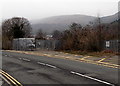
Railway compound, Miskin
Looking across the B4275 Miskin Road towards a fenced compound
alongside a railway line, about 250 metres SE of Mountain Ash railway station.
Image: © Jaggery
Taken: 30 Jan 2014
0.10 miles