IMAGES TAKEN NEAR TO
Incline Top, MOUNTAIN ASH, CF45 4EH
Introduction
This page details the photographs taken nearby to Incline Top, CF45 4EH by members of the Geograph project.
The Geograph project started in 2005 with the aim of publishing, organising and preserving representative images for every square kilometre of Great Britain, Ireland and the Isle of Man.

There are currently over 7.5m images from over14,400 individuals and you can help contribute to the project by visiting https://www.geograph.org.uk
Image Map (Loading...)


Getting Data...Please wait
Leaflet Map data © OpenStreetMap
Images are licensed for reuse under creativecommons.org/licenses/by-sa/2.0
Notes
- Clicking on the map will re-center to the selected point.
- The higher the marker number, the further away the image location is from the centre of the postcode.
Image Listing (34 Images Found)
Images are licensed for reuse under creativecommons.org/licenses/by-sa/2.0
Image
Details
Distance
1
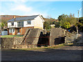
Route of the Glamorgan Canal in Abercynon
Most of lock 16-17, the junction lock still stands, and is now part of a private garden.
Image: © Gareth James
Taken: 21 Oct 2016
0.11 miles
2
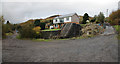
Canal Junction Abercynon
This is the site of the junction of the Aberdare and Glamorganshire Canals. The Aberdare went off to the left and the Glamorganshire up through the lock remains to the right of the lock cottage.
Image: © Guy Butler-Madden
Taken: 15 Nov 2005
0.12 miles
3
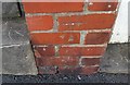
Ordnance Survey Cut Mark
This OS cut mark can be found on the brick post of No68 Lock Street It marks a point 119.085m above mean sea level.
Image: © Adrian Dust
Taken: 7 Oct 2018
0.12 miles
4
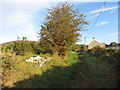
Route of the Glamorgan Canal in Abercynon
The canal here is now a footpath; the remains of lock 18-19 can be seen on the left.
Image: © Gareth James
Taken: 21 Oct 2016
0.15 miles
5
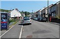
Argyle Street, Abercynon
Viewed from the Glancynon Terrace end. On the right, there is an Olympic-themed BT advert on the phonebox. This view was taken during the fortnight of the 2012 Olympic Games.
Image: © Jaggery
Taken: 10 Aug 2012
0.16 miles
6
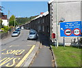
Restrictions ahead, Greenfield Terrace, Abercynon
A large blue sign at the southern end of Greenfield Terrace shows
a 7.5 tonne weight restriction and an 8' 6" width restriction 510 yards ahead.
Image: © Jaggery
Taken: 10 Aug 2012
0.18 miles
7
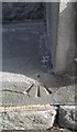
Ordnance Survey Pivot
This OS pivot can be found on the step of No11 Greenfield Terrace. It marks a point 102.053m above mean sea level.
Image: © Adrian Dust
Taken: 7 Oct 2018
0.18 miles
8
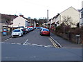
Argyle Street, Abercynon
Looking north from the corner of Glancynon Terrace and Alexandra Road.
Image: © Jaggery
Taken: 30 Jan 2016
0.18 miles
9
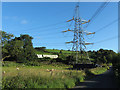
Pylon beside country lane to north of Abercynon
Image: © Gareth James
Taken: 6 Aug 2016
0.19 miles
10
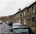
Greenfield Terrace houses, Abercynon
Greenfield Terrace leads to a primary school named Ysgol Gynradd Gymraeg.
Image: © Jaggery
Taken: 6 Feb 2019
0.19 miles