IMAGES TAKEN NEAR TO
New Road, MOUNTAIN ASH, CF45 4BZ
Introduction
This page details the photographs taken nearby to New Road, CF45 4BZ by members of the Geograph project.
The Geograph project started in 2005 with the aim of publishing, organising and preserving representative images for every square kilometre of Great Britain, Ireland and the Isle of Man.

There are currently over 7.5m images from over14,400 individuals and you can help contribute to the project by visiting https://www.geograph.org.uk
Image Map
Images are licensed for reuse under creativecommons.org/licenses/by-sa/2.0
Notes
- Clicking on the map will re-center to the selected point.
- The higher the marker number, the further away the image location is from the centre of the postcode.
Image Listing (56 Images Found)
Images are licensed for reuse under creativecommons.org/licenses/by-sa/2.0
Image
Details
Distance
1
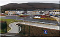
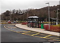
Cynon Valley Hospital, Mountain Ash
Viewed across the A4059 New Road from a footbridge. Cynon Valley Hospital was built in the second decade of 21st century. The hospital buildings and the adjacent parking areas have a graceful curved shape, following the curved northern bank of a river, Afon Cynon, behind the hospital.
Image: © Jaggery
Taken: 25 Jan 2014
0.01 miles
2
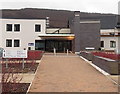
Main entrance to Cynon Valley Hospital, Mountain Ash
Occupying a site on the north bank of a river, Afon Cynon, the hospital was built in the second decade of the 21st century.
Image: © Jaggery
Taken: 25 Jan 2014
0.01 miles
3
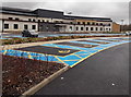
Blue badge parking area at Cynon Valley Hospital, Mountain Ash
The parking bays nearest the hospital main entrance are designated for use by blue badge holders.
Image: © Jaggery
Taken: 25 Jan 2014
0.04 miles
4
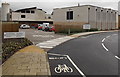
Bicycle parking area at Cynon Valley Hospital, Mountain Ash
Built in the second decade of the 21st century, the hospital has a large covered parking area for bicycles.
Image: © Jaggery
Taken: 25 Jan 2014
0.05 miles
5
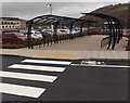
Bus shelter, Cynon Valley Hospital, Mountain Ash
Behind the bus shelter is a covered parking area for bicycles. http://www.geograph.org.uk/photo/3958380
Image: © Jaggery
Taken: 25 Jan 2014
0.05 miles
6
Service Yard at Cynon Valley Hospital, Mountain Ash
Located in the SE corner of the hospital. The sign shows All Deliveries, Service Yard, Mortuary. There is a gap of a few metres in the marked cycle lane.
Image: © Jaggery
Taken: 25 Jan 2014
0.07 miles
7
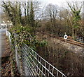
W railway sign, Mountain Ash
Viewed from Aberdare Road opposite Mountain Ash cemetery. Located alongside the Aberdare Branch of the Merthyr Line railway, the W sign originally instructed the drivers of steam locomotives to sound the whistle. The modern equivalent is for drivers of diesels to sound the horn.
Image: © Jaggery
Taken: 19 Feb 2014
0.08 miles
8
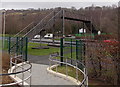
New Road footbridge, Mountain Ash
A safe route for walkers over the busy A4059 New Road, from Cynon Valley Hospital
on this side to Mountain Ash Comprehensive School ahead.
Image: © Jaggery
Taken: 25 Jan 2014
0.08 miles
9
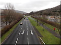
New Road towards the centre of Mountain Ash
Looking SE along the A4059 New Road from this http://www.geograph.org.uk/photo/3958399 footbridge.
Cynon Valley Hospital http://www.geograph.org.uk/photo/3958401 is on the right.
Image: © Jaggery
Taken: 25 Jan 2014
0.08 miles
10
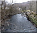
Afon Cynon near Cynon Valley Hospital, Mountain Ash
Viewed from this http://www.geograph.org.uk/photo/3982709 footbridge looking downstream.
The hospital http://www.geograph.org.uk/photo/3958401 is faintly visible behind trees.
Image: © Jaggery
Taken: 25 Jan 2014
0.09 miles