1
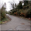
Parry's Drive, Ynysboeth
Dead-end road opposite Valley View. https://www.geograph.org.uk/photo/6053740
Image: © Jaggery
Taken: 6 Feb 2019
0.01 miles
2
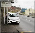
Ynysboeth village boundary sign
Alongside the B4275 Abercynon Road at the southern edge of the village, viewed from Pontcynon.
The sign shows Ynys-boeth, the Welsh form of the village name usually written Ynysboeth in English.
Image: © Jaggery
Taken: 6 Feb 2019
0.02 miles
3
Junction of Abercynon Road and Nant-y-fedw, Ynysboeth
From the left, the road named Nant-y-fedw ascends to the B4275 Abercynon Road.
Image: © Jaggery
Taken: 6 Feb 2019
0.03 miles
4
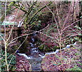
Brook on the southwest side of Abercynon Road, Pontcynon
A minor tributary of the River Cynon, the brook flows towards the camera at the edge of the B4275 Abercynon Road. Two flows of white water, one from the left and one from the right, enter the brook here.
Image: © Jaggery
Taken: 6 Feb 2019
0.03 miles
5
White water enters a brook, Pontcynon
Water issues from a culvert into this https://www.geograph.org.uk/photo/6053789 brook, a minor tributary of the River Cynon.
Image: © Jaggery
Taken: 6 Feb 2019
0.04 miles
6
Nant-y-fedw, Ynysboeth
The road named Nant-y-fedw descends from the B4275 Abercynon Road
towards Selina Road and the valley of the River Cynon.
Image: © Jaggery
Taken: 6 Feb 2019
0.04 miles
7
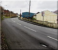
Up a bend in Abercynon Road, Ynsyboeth
The B4275 Abercynon Road ascends towards Tyntetown.
Image: © Jaggery
Taken: 6 Feb 2019
0.05 miles
8
Potchy's MOT Station, Ynysboeth
Viewed across the B4275 Abercynon Road. Text in view in February 2019 includes
All Makes of Vehicles Repaired and Serviced.
Image: © Jaggery
Taken: 6 Feb 2019
0.05 miles
9
Ordnance Survey Cut Mark
This very damaged OS cut mark can be found on No261 Abercynon Road. It marks a point 110.252m above mean sea level.
Image: © Adrian Dust
Taken: 27 May 2019
0.06 miles
10
Valley View, Ynysboeth
Modern houses west of the B4275 Abercynon Road.
Image: © Jaggery
Taken: 6 Feb 2019
0.06 miles


