IMAGES TAKEN NEAR TO
Lewis Street, MOUNTAIN ASH, CF45 4AY
Introduction
This page details the photographs taken nearby to Lewis Street, CF45 4AY by members of the Geograph project.
The Geograph project started in 2005 with the aim of publishing, organising and preserving representative images for every square kilometre of Great Britain, Ireland and the Isle of Man.

There are currently over 7.5m images from over14,400 individuals and you can help contribute to the project by visiting https://www.geograph.org.uk
Image Map
Images are licensed for reuse under creativecommons.org/licenses/by-sa/2.0
Notes
- Clicking on the map will re-center to the selected point.
- The higher the marker number, the further away the image location is from the centre of the postcode.
Image Listing (40 Images Found)
Images are licensed for reuse under creativecommons.org/licenses/by-sa/2.0
Image
Details
Distance
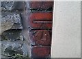
1
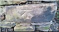
Ordnance Survey Cut Mark
This OS cut mark can be found on the garage at the road junction. It marks a point 152.242m above mean sea level.
Image: © Adrian Dust
Taken: 19 Jan 2018
0.02 miles
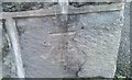
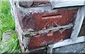
2
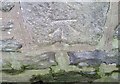
Ordnance Survey Cut Mark
This OS cut mark can be found on the wall of Melbourne House, Allen Street. It marks a point 140.525m above mean sea level.
Image: © Adrian Dust
Taken: 19 Jan 2018
0.05 miles
3
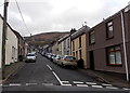
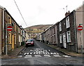
Phillip Street, Mountain Ash
Looking NE away from the Jeffrey Street junction.
Image: © Jaggery
Taken: 25 Jan 2014
0.06 miles
4
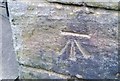
Ordnance Survey Cut Mark
This OS cut mark can be found on the gatepost of Maes Caradog, Aberffrwd Road. It marks a point 140.071m above mean sea level.
Image: © Adrian Dust
Taken: 19 Jan 2018
0.07 miles
5
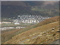
Looking down, on Mountain Ash, from Craig Darrenlas
Image: © Roger Cornfoot
Taken: 14 Mar 2009
0.10 miles
6
Ordnance Survey Cut Mark
This OS cut mark can be found on the wall of No10 Granville Terrace. It marks a point 130.049m above mean sea level.
Image: © Adrian Dust
Taken: 19 Jan 2018
0.11 miles
7
No entry to Seymour Street, Mountain Ash
Viewed from Jeffrey Street where two-way traffic along Seymour Street behind the camera becomes one way.
Image: © Jaggery
Taken: 25 Jan 2014
0.12 miles
9
Ordnance Survey Cut Mark
This OS cut mark can be found on No21 Beckett Street. It marks a point 130.406m above mean sea level.
Image: © Adrian Dust
Taken: 19 Jan 2018
0.13 miles
10
Ordnance Survey Cut Mark
This OS cut mark can be found on the wall of No1 Beckett Street. It marks a point 123.612m above mean sea level.
Image: © Adrian Dust
Taken: 19 Jan 2018
0.16 miles