IMAGES TAKEN NEAR TO
Ffrwd Crescent, MOUNTAIN ASH, CF45 4AA
Introduction
This page details the photographs taken nearby to Ffrwd Crescent, CF45 4AA by members of the Geograph project.
The Geograph project started in 2005 with the aim of publishing, organising and preserving representative images for every square kilometre of Great Britain, Ireland and the Isle of Man.

There are currently over 7.5m images from over14,400 individuals and you can help contribute to the project by visiting https://www.geograph.org.uk
Image Map
Images are licensed for reuse under creativecommons.org/licenses/by-sa/2.0
Notes
- Clicking on the map will re-center to the selected point.
- The higher the marker number, the further away the image location is from the centre of the postcode.
Image Listing (130 Images Found)
Images are licensed for reuse under creativecommons.org/licenses/by-sa/2.0
Image
Details
Distance
1
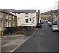
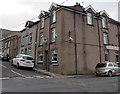
Southern end of Allen Street, Mountain Ash
Looking north towards Jeffrey Street.
Image: © Jaggery
Taken: 25 Jan 2014
0.02 miles
2
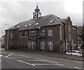
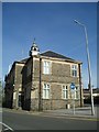
North side of Mountain Ash Town Hall
Viewed across New Road. Now in use as Rhondda Cynon Taf County Borough Council offices, Mountain Ash Town Hall was built in 1904 as the headquarters of Mountain Ash UDC (Urban District Council). This usage continued until the local government reorganisation of April 1974.
http://www.geograph.org.uk/photo/3830546 to a view of the south side.
Image: © Jaggery
Taken: 25 Jan 2014
0.02 miles
3
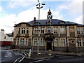
South side of Mountain Ash Town Hall
Now in use as Rhondda Cynon Taf County Borough Council offices, Mountain Ash Town Hall was built in 1904 as the headquarters of Mountain Ash UDC (Urban District Council). This usage continued until the local government reorganisation of April 1974.
http://www.geograph.org.uk/photo/3845098 to a view of the north side.
Image: © Jaggery
Taken: 25 Jan 2014
0.02 miles
4
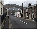
SW end of Phillip Street, Mountain Ash
Viewed from near the Jeffrey Street junction looking towards the Town Hall. http://www.geograph.org.uk/photo/3845098
Metal railings block vehicular access to and from New Road.
Image: © Jaggery
Taken: 25 Jan 2014
0.03 miles
5
Mountain Ash Town Hall
A Grade II listed building, constructed in 1904 for the Mountain Ash Urban District Council.
Image: © Chris Andrews
Taken: 11 Apr 2017
0.03 miles
6
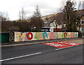
Colourful side of a river bridge in Mountain Ash
Among illustrations with a local theme, letters show Mountain Ash. The letters on the similarly colourful side opposite show Aberpennar, the Welsh name of the town. The bridge crosses the Afon Cynon.
Image: © Jaggery
Taken: 25 Jan 2014
0.03 miles
7
George's Plaice, Mountain Ash
Fish & chips shop on the corner of Jeffrey Street and Allen Street.
Image: © Jaggery
Taken: 25 Jan 2014
0.03 miles
8
Three Jeffrey Street businesses in Mountain Ash
The Jeffreys Arms Family Restaurant is on the right. In the corner premises,
Lee's barber shop is on the ground, Elle Hair Design is on the first floor.
Image: © Jaggery
Taken: 25 Jan 2014
0.04 miles
9
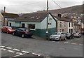
Butchers Arms, Mountain Ash
Pub on the corner of Allen Street and Jeffrey Street.
Image: © Jaggery
Taken: 25 Jan 2014
0.04 miles
10
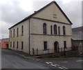
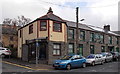
Former Bethania chapel, Mountain Ash
On the corner of Phillip Street and Jeffrey Street. The original 1854 chapel was rebuilt in 1859.
Grade II listed in 1999. There was no nameboard here at the early 2014 date of this view.
One source states that the church closed in 2011.
Image: © Jaggery
Taken: 25 Jan 2014
0.04 miles