IMAGES TAKEN NEAR TO
MOUNTAIN ASH, CF45 3YJ
Introduction
This page details the photographs taken nearby to CF45 3YJ by members of the Geograph project.
The Geograph project started in 2005 with the aim of publishing, organising and preserving representative images for every square kilometre of Great Britain, Ireland and the Isle of Man.

There are currently over 7.5m images from over14,400 individuals and you can help contribute to the project by visiting https://www.geograph.org.uk
Image Map
Images are licensed for reuse under creativecommons.org/licenses/by-sa/2.0
Notes
- Clicking on the map will re-center to the selected point.
- The higher the marker number, the further away the image location is from the centre of the postcode.
Image Listing (3 Images Found)
Images are licensed for reuse under creativecommons.org/licenses/by-sa/2.0
Image
Details
Distance
1
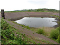
Perthgelyn Reservoir
Currently unused, the 31-million-gallon Perthgelyn Reservoir was completed in 1903 to supply water to houses in the Cynon Valley.
Image: © Gareth James
Taken: 14 May 2016
0.09 miles
3
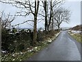
Country lane
Country lane at Perthcelyn.
Image: © Alan Hughes
Taken: 1 Feb 2021
0.18 miles