IMAGES TAKEN NEAR TO
Church Street, MOUNTAIN ASH, CF45 3YE
Introduction
This page details the photographs taken nearby to Church Street, CF45 3YE by members of the Geograph project.
The Geograph project started in 2005 with the aim of publishing, organising and preserving representative images for every square kilometre of Great Britain, Ireland and the Isle of Man.

There are currently over 7.5m images from over14,400 individuals and you can help contribute to the project by visiting https://www.geograph.org.uk
Image Map
Images are licensed for reuse under creativecommons.org/licenses/by-sa/2.0
Notes
- Clicking on the map will re-center to the selected point.
- The higher the marker number, the further away the image location is from the centre of the postcode.
Image Listing (113 Images Found)
Images are licensed for reuse under creativecommons.org/licenses/by-sa/2.0
Image
Details
Distance
1
Bethel chapel, Penrhiwceiber
Bethel chapel, now a builders merchant.
Image: © Alan Hughes
Taken: 27 Mar 2019
0.01 miles
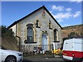
2

Former Bethel chapel, Penrhiwceiber
The year 1894 is inscribed on a tablet on the building, now the premises of J.W.Jones & Sons.
Image: © Jaggery
Taken: 4 Feb 2014
0.01 miles
3

Penrhiwceiber Library
This branch of Rhondda Cynon Taf Council's library service opened in Church Street in 2005.
Image: © Jaggery
Taken: 4 Feb 2014
0.02 miles
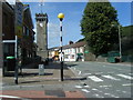
4
Clock Tower
Penrhiwceiber clock tower war memorial.
Image: © Alan Hughes
Taken: 27 Mar 2019
0.03 miles
5

Punjabi Inn Penrhiwceiber
Indian cuisine takeaway at 5 Penrhiwceiber Road.
Image: © Jaggery
Taken: 4 Feb 2014
0.03 miles
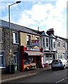
6

Blooms 'R' Us, Penrhiwceiber
Florist shop at 1 Penrhiwceiber Road. Next door is The Clock Fish Bar,
opposite the War Memorial Clock Tower. http://www.geograph.org.uk/photo/3834145
Image: © Jaggery
Taken: 4 Feb 2014
0.03 miles
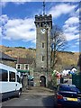
7
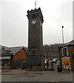
War Memorial Clock Tower, Penrhiwceiber
Viewed across the B4275 Penrhiwceiber Road. Financed by public subscription, completed in 1926. The central part of the large plaque at the base of the tower records the names of the local men who were killed in The Great War 1914-1918, now usually known as the First World War. The plaque was later extended on the left and right to show the names of those killed in the Second World War.
Image: © Jaggery
Taken: 30 Jan 2014
0.03 miles
8
PJS Better Buys, Penrhiwceiber
DIY store in Penrhiwceiber Road. Next door is Cut Loose unisex hair and beauty studio.
Image: © Jaggery
Taken: 4 Feb 2014
0.03 miles
9
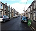
Glanlay Street, Penrhiwceiber
Viewed from Cynon Terrace looking NNW towards Cross Street.
Image: © Jaggery
Taken: 4 Feb 2014
0.03 miles