IMAGES TAKEN NEAR TO
Penybryn Terrace, MOUNTAIN ASH, CF45 3TJ
Introduction
This page details the photographs taken nearby to Penybryn Terrace, CF45 3TJ by members of the Geograph project.
The Geograph project started in 2005 with the aim of publishing, organising and preserving representative images for every square kilometre of Great Britain, Ireland and the Isle of Man.

There are currently over 7.5m images from over14,400 individuals and you can help contribute to the project by visiting https://www.geograph.org.uk
Image Map
Images are licensed for reuse under creativecommons.org/licenses/by-sa/2.0
Notes
- Clicking on the map will re-center to the selected point.
- The higher the marker number, the further away the image location is from the centre of the postcode.
Image Listing (119 Images Found)
Images are licensed for reuse under creativecommons.org/licenses/by-sa/2.0
Image
Details
Distance
1
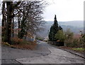
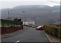
Penybryn Road, Perthcelyn
Penybryn Road descends from Perthcelyn towards Penrhiwceiber.
Image: © Jaggery
Taken: 30 Jan 2014
0.05 miles
2
Perthcelyn Community Primary School
Set back 100 metres from the north side of Glamorgan Street, Perthcelyn.
Image: © Jaggery
Taken: 30 Jan 2014
0.06 miles
3
Entrance gates to Perthcelyn Community Primary School
Located between Glamorgan Street and the school. http://www.geograph.org.uk/photo/3964021 One of the messages on the board is
STAFF ONLY. No unauthorised persons or vehicles beyond this point.
Image: © Jaggery
Taken: 30 Jan 2014
0.10 miles
4
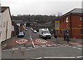
Cross Street, Penrhiwceiber
Viewed across the B4275 which is Penrhiwceiber Road north (right) of Cross Street and Rheola Street on the south side.
Image: © Jaggery
Taken: 30 Jan 2014
0.10 miles
5
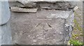
Ordnance Survey Cut Mark
This OS cut mark can be found on No87 Morris Avenue. It marks a point 127.101m above mean sea level.
Image: © Adrian Dust
Taken: 15 Apr 2018
0.10 miles
6

Penrhiwceiber Primary School
This is the southern (Cross Street) side of the school formed in September 2003 from the amalgamation
of Penrhiwceiber Infants School and Penrhiwceiber Junior School, which had existed for more than a century.
Image: © Jaggery
Taken: 4 Feb 2014
0.11 miles
7
Oak Terrace and misty hills, Perthcelyn
Viewed from the corner of Hawthorn Terrace looking towards Oak Terrace,
and the misty hillside beyond, in January 2014.
Image: © Jaggery
Taken: 30 Jan 2014
0.11 miles
8
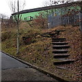
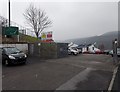
Steps up to Perthcelyn Community Centre
The steps give walkers a short cut from Penybryn Road,
past the edge of an electricity substation, to the community centre. http://www.geograph.org.uk/photo/3963891
Image: © Jaggery
Taken: 30 Jan 2014
0.11 miles
9
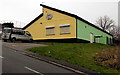
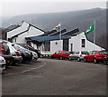
Yellow and green in Perthcelyn
The conspicuously painted building is Perthcelyn Community Centre, viewed across Glamorgan Street. The name on the wall includes depictions of two hands. The year 1976 is on the left hand, 2006 on the right hand.
Image: © Jaggery
Taken: 30 Jan 2014
0.11 miles
10
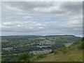
Penrhiwceiber and Mountain Ash
Welsh communities in the Cynon Valley.
Image: © Alan Hughes
Taken: 19 Jun 2022
0.11 miles