1
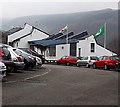
Penybryn Road, Perthcelyn
Penybryn Road descends from Perthcelyn towards Penrhiwceiber.
Image: © Jaggery
Taken: 30 Jan 2014
0.02 miles
2
Ordnance Survey Cut Mark
This OS cut mark can be found on No87 Morris Avenue. It marks a point 127.101m above mean sea level.
Image: © Adrian Dust
Taken: 15 Apr 2018
0.09 miles
3
Cross Street, Penrhiwceiber
Viewed across the B4275 which is Penrhiwceiber Road north (right) of Cross Street and Rheola Street on the south side.
Image: © Jaggery
Taken: 30 Jan 2014
0.09 miles
4
Perthcelyn Community Primary School
Set back 100 metres from the north side of Glamorgan Street, Perthcelyn.
Image: © Jaggery
Taken: 30 Jan 2014
0.10 miles
5
Penrhiwceiber Primary School
This is the southern (Cross Street) side of the school formed in September 2003 from the amalgamation
of Penrhiwceiber Infants School and Penrhiwceiber Junior School, which had existed for more than a century.
Image: © Jaggery
Taken: 4 Feb 2014
0.10 miles
6
Entrance gates to Perthcelyn Community Primary School
Located between Glamorgan Street and the school. http://www.geograph.org.uk/photo/3964021 One of the messages on the board is
STAFF ONLY. No unauthorised persons or vehicles beyond this point.
Image: © Jaggery
Taken: 30 Jan 2014
0.11 miles
7
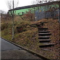
Steps up to Perthcelyn Community Centre
The steps give walkers a short cut from Penybryn Road,
past the edge of an electricity substation, to the community centre. http://www.geograph.org.uk/photo/3963891
Image: © Jaggery
Taken: 30 Jan 2014
0.11 miles
8
Perthcelyn Infants School
Viewed from Penybryn Road. This was the only school in Perthcelyn until the opening of Perthcelyn Community Primary School nearby.
Image: © Jaggery
Taken: 30 Jan 2014
0.11 miles
9
Yellow and green in Perthcelyn
The conspicuously painted building is Perthcelyn Community Centre, viewed across Glamorgan Street. The name on the wall includes depictions of two hands. The year 1976 is on the left hand, 2006 on the right hand.
Image: © Jaggery
Taken: 30 Jan 2014
0.11 miles
10
Yellow side of two-tone Perthcelyn Community Centre
Viewed across Glamorgan Street. A view http://www.geograph.org.uk/photo/3963891 from another angle shows its green side as well.
Image: © Jaggery
Taken: 30 Jan 2014
0.12 miles


