IMAGES TAKEN NEAR TO
Park Hill, MOUNTAIN ASH, CF45 3RL
Introduction
This page details the photographs taken nearby to Park Hill, CF45 3RL by members of the Geograph project.
The Geograph project started in 2005 with the aim of publishing, organising and preserving representative images for every square kilometre of Great Britain, Ireland and the Isle of Man.

There are currently over 7.5m images from over14,400 individuals and you can help contribute to the project by visiting https://www.geograph.org.uk
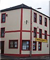
Image Map
Images are licensed for reuse under creativecommons.org/licenses/by-sa/2.0
Notes
- Clicking on the map will re-center to the selected point.
- The higher the marker number, the further away the image location is from the centre of the postcode.
Image Listing (111 Images Found)
Images are licensed for reuse under creativecommons.org/licenses/by-sa/2.0
Image
Details
Distance
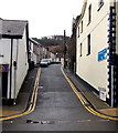
2
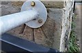
Ordnance Survey Cut Mark
This OS cut mark can be found on the Police Station. It marks a point 123.977m above mean sea level.
Image: © Adrian Dust
Taken: 19 Jan 2018
0.07 miles
3
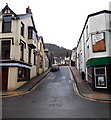
Pryce Street, Mountain Ash
Viewed across Oxford Street.
Image: © Jaggery
Taken: 19 Feb 2014
0.09 miles
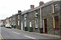
4
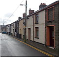
Duffryn Street houses south of Union Street, Mountain Ash
The house on the right has a window frame but no window at upstairs level.
Image: © Jaggery
Taken: 19 Feb 2014
0.09 miles
5
Union Street, Mountain Ash
Union Street ascends from Commercial Street towards Duffryn Street.
Image: © Jaggery
Taken: 19 Feb 2014
0.10 miles
6
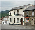
The Napiers Arms, Mountain Ash
Pub on the corner of High Street and Dover Street.
Image: © Jaggery
Taken: 26 May 2010
0.10 miles
7
Napier Street, Mountain Ash
Viewed from the corner of Knight Street.
Image: © Jaggery
Taken: 26 May 2010
0.10 miles
8
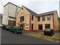
Mountain Ash Library
Part of the Rhondda Cynon Taf County Borough Council library service, the Mountain Ash branch has been located here in Knight Street since April 1997.
Image: © Jaggery
Taken: 25 Jan 2014
0.10 miles
9
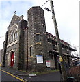
Providence Baptist Church viewed from the east, Mountain Ash
The Union Street church has PROVIDENCE CONGREGATIONAL CHURCH inscribed in stone above the doorway. The nameboard at the February 2014 date of this view shows Providence Baptist Church.
Image: © Jaggery
Taken: 19 Feb 2014
0.12 miles
10
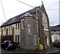
Providence Baptist Church viewed from the west, Mountain Ash
The Union Street church has PROVIDENCE CONGREGATIONAL CHURCH inscribed in stone above the doorway. The nameboard at the February 2014 date of this view shows Providence Baptist Church.
Image: © Jaggery
Taken: 19 Feb 2014
0.12 miles