IMAGES TAKEN NEAR TO
Monmouth Street, MOUNTAIN ASH, CF45 3NJ
Introduction
This page details the photographs taken nearby to Monmouth Street, CF45 3NJ by members of the Geograph project.
The Geograph project started in 2005 with the aim of publishing, organising and preserving representative images for every square kilometre of Great Britain, Ireland and the Isle of Man.

There are currently over 7.5m images from over14,400 individuals and you can help contribute to the project by visiting https://www.geograph.org.uk
Image Map (Loading...)


Getting Data...Please wait
Leaflet Map data © OpenStreetMap
Images are licensed for reuse under creativecommons.org/licenses/by-sa/2.0
Notes
- Clicking on the map will re-center to the selected point.
- The higher the marker number, the further away the image location is from the centre of the postcode.
Image Listing (51 Images Found)
Images are licensed for reuse under creativecommons.org/licenses/by-sa/2.0
Image
Details
Distance
1
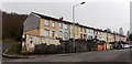
Long row of houses, Monmouth Street, Perthcelyn
The row extends for about 100 metres.
Image: © Jaggery
Taken: 30 Jan 2014
0.03 miles
2

Give way 50 yards ahead, Glamorgan Street, Perthcelyn
The sign on the left draws attention to traffic calming http://www.geograph.org.uk/photo/3950322 ahead.
Image: © Jaggery
Taken: 30 Jan 2014
0.03 miles
3

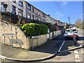
Down Monmouth Street, Perthcelyn
Monmouth Street is parallel with Glamorgan Street. Access to both ends of the street is from Glamorgan Street. The houses on the right are opposite the backs of Glamorgan Street houses on the left.
Image: © Jaggery
Taken: 30 Jan 2014
0.03 miles
4
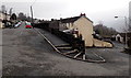
Road junction
Junction of Monmouth Street and Glamorgan Street at Perthcelyn.
Image: © Alan Hughes
Taken: 27 Mar 2019
0.04 miles
5
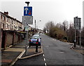
Traffic calming in Perthcelyn
This narrowing of the Glamorgan Street roadway is intended to slow down traffic through
a residential area. Traffic ascending the hill has priority over descending traffic.
Image: © Jaggery
Taken: 30 Jan 2014
0.04 miles
6
Hairpin bend in Perthcelyn
The road from Monmouth Street on the left to Glamorgan Street on the right.
Image: © Jaggery
Taken: 30 Jan 2014
0.04 miles
7
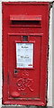
King George VI postbox in Perthcelyn
Located here http://www.geograph.org.uk/photo/3950268 on the Monmouth Street side of the Glamorgan Street junction.
The monogram dates the box to the reign of King George VI (December 1936- February 1952).
Image: © Jaggery
Taken: 30 Jan 2014
0.04 miles
8
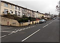
Long row of houses, Glamorgan Street, Perthcelyn
A long row of houses extends for 150 metres from the Monmouth Street junction.
The postbox http://www.geograph.org.uk/photo/3950271 in the wall has a King George VI monogram.
Image: © Jaggery
Taken: 30 Jan 2014
0.04 miles
9
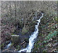
White water stream, Perthcelyn
A small tributary of the Afon Cynon tumbles down a hillside towards this http://www.geograph.org.uk/photo/3950290 footbridge.
Image: © Jaggery
Taken: 30 Jan 2014
0.05 miles
10
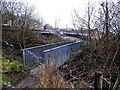
Footbridge over a small stream, Perthcelyn
The stream is an unnamed tributary of the Afon Cynon. Monmouth Street is in the background.
Image: © Jaggery
Taken: 30 Jan 2014
0.05 miles