IMAGES TAKEN NEAR TO
Cwrt Llanwonno, MOUNTAIN ASH, CF45 3NF
Introduction
This page details the photographs taken nearby to Cwrt Llanwonno, CF45 3NF by members of the Geograph project.
The Geograph project started in 2005 with the aim of publishing, organising and preserving representative images for every square kilometre of Great Britain, Ireland and the Isle of Man.

There are currently over 7.5m images from over14,400 individuals and you can help contribute to the project by visiting https://www.geograph.org.uk
Image Map
Images are licensed for reuse under creativecommons.org/licenses/by-sa/2.0
Notes
- Clicking on the map will re-center to the selected point.
- The higher the marker number, the further away the image location is from the centre of the postcode.
Image Listing (37 Images Found)
Images are licensed for reuse under creativecommons.org/licenses/by-sa/2.0
Image
Details
Distance
1
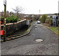
Western end of York Street, Miskin
York Street ends at the edge of trees ahead. There may be a track through the trees to Llanwonno Road, but I did not explore that possibility.
Image: © Jaggery
Taken: 25 Jan 2014
0.07 miles

3
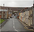
Bailey Street, Miskin
Viewed from Miskin Road. Bailey Street is mainly residential, with a few shops.
Image: © Jaggery
Taken: 25 Jan 2014
0.11 miles
4
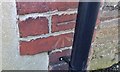
Ordnance Survey Cut Mark
This OS cut mark can be found on No16 Ceridwen Street. It marks a point 174.486m above mean sea level.
Image: © Adrian Dust
Taken: 19 Jan 2018
0.11 miles
5
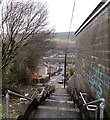
Steps from York Street to Bailey Street, Miskin
Image: © Jaggery
Taken: 25 Jan 2014
0.12 miles
6
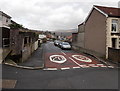
20mph speed limit along Bryn Ifor, Miskin
Viewed across Bailey Street from the corner of Clarence Street.
Image: © Jaggery
Taken: 25 Jan 2014
0.13 miles
7
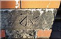
Ordnance Survey Cut Mark
This OS cut mark can be found on the gatepost of the school. It marks a point 156.146m above mean sea level.
Image: © Adrian Dust
Taken: 19 Jan 2018
0.13 miles
8

Clarence Street, Miskin
Looking NNW towards Bailey Street.
Image: © Jaggery
Taken: 30 Jan 2014
0.14 miles
9
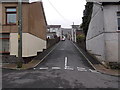
Up to York Street from Victoria Street, Miskin
An unnamed street climbs away from Victoria Street.
Image: © Jaggery
Taken: 30 Jan 2014
0.15 miles
10
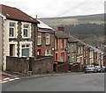
North side of Bailey Street, Miskin
Bailey Street descends from the corner of Bryn Ifor http://www.geograph.org.uk/photo/3826711 towards Miskin Road.
Image: © Jaggery
Taken: 25 Jan 2014
0.16 miles