IMAGES TAKEN NEAR TO
Holly Row, MOUNTAIN ASH, CF45 3EX
Introduction
This page details the photographs taken nearby to Holly Row, CF45 3EX by members of the Geograph project.
The Geograph project started in 2005 with the aim of publishing, organising and preserving representative images for every square kilometre of Great Britain, Ireland and the Isle of Man.

There are currently over 7.5m images from over14,400 individuals and you can help contribute to the project by visiting https://www.geograph.org.uk
Image Map
Images are licensed for reuse under creativecommons.org/licenses/by-sa/2.0
Notes
- Clicking on the map will re-center to the selected point.
- The higher the marker number, the further away the image location is from the centre of the postcode.
Image Listing (44 Images Found)
Images are licensed for reuse under creativecommons.org/licenses/by-sa/2.0
Image
Details
Distance
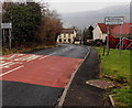
1
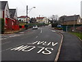
Up Hawthorn Terrace, Perthcelyn
Hawthorn Terrace climbs towards Llanwonno Road. The right turn is into Holly Row.
Image: © Jaggery
Taken: 30 Jan 2014
0.02 miles
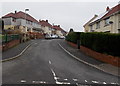
2
Ash Grove, Perthcelyn
Viewed from the corner of Hawthorn Terrace.
Image: © Jaggery
Taken: 30 Jan 2014
0.03 miles
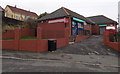
3
Credit Union in Perthcelyn
Located in Hawthorn Terrace opposite Brynheulog. Credit Unions are financial co-operatives that are community-focused and controlled by their members, offering savings and loans.
Image: © Jaggery
Taken: 30 Jan 2014
0.04 miles
4
Western boundary of Perthcelyn
Llanwonno Road from Miskin reaches Perthcelyn near Penrhiwceiber.
Image: © Jaggery
Taken: 30 Jan 2014
0.05 miles
5
Southern boundary of Perthcelyn
The road north from Ynysybwl reaches Perthcelyn near Penrhiwceiber.
Image: © Jaggery
Taken: 30 Jan 2014
0.05 miles
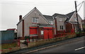
6
Perthcelyn Food Market and off-licence
Viewed across Brynheulog.
Image: © Jaggery
Taken: 30 Jan 2014
0.06 miles
7
Semis and hedges in Brynheulog, Perthcelyn
Semi-detached houses in one of several arms or branches of Brynheulog.
Image: © Jaggery
Taken: 30 Jan 2014
0.06 miles
8
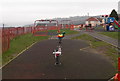
Brynheulog, Perthcelyn
Looking south along Brynheulog past the edge of a children's play area. http://www.geograph.org.uk/photo/3969269
Image: © Jaggery
Taken: 30 Jan 2014
0.06 miles
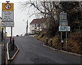
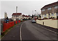
9
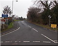
Road to Ynysybwl and Ferndale from Perthcelyn
The 30mph speed limit increases to the National Speed Limit ahead. Signs show 2 (miles) to St Gwynno Church and to Ynysybwl, 4 miles to Ferndale. Another sign shows Unsuitable for heavy goods vehicles.
Image: © Jaggery
Taken: 30 Jan 2014
0.07 miles
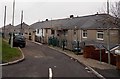
10
Brynheulog play area, Perthcelyn
Located on the east side of the street named Brynheulog. http://www.geograph.org.uk/photo/3969274
Image: © Jaggery
Taken: 30 Jan 2014
0.07 miles