IMAGES TAKEN NEAR TO
Clarence Street, MOUNTAIN ASH, CF45 3BD
Introduction
This page details the photographs taken nearby to Clarence Street, CF45 3BD by members of the Geograph project.
The Geograph project started in 2005 with the aim of publishing, organising and preserving representative images for every square kilometre of Great Britain, Ireland and the Isle of Man.

There are currently over 7.5m images from over14,400 individuals and you can help contribute to the project by visiting https://www.geograph.org.uk
Image Map
Images are licensed for reuse under creativecommons.org/licenses/by-sa/2.0
Notes
- Clicking on the map will re-center to the selected point.
- The higher the marker number, the further away the image location is from the centre of the postcode.
Image Listing (66 Images Found)
Images are licensed for reuse under creativecommons.org/licenses/by-sa/2.0
Image
Details
Distance
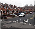
1
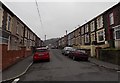
Clarence Street, Miskin
Looking SSE towards the Mount Pleasant Terrace junction.
Image: © Jaggery
Taken: 30 Jan 2014
0.01 miles
2
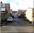
Mount Pleasant Terrace, Miskin
Viewed across Glyngwyn Street looking up Mount Pleasant Terrace towards Clarence Street.
Image: © Jaggery
Taken: 4 Feb 2014
0.01 miles
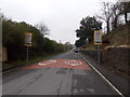
3
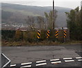
York Street warning signs, Miskin
Located at a T-junction at the bottom of a steep gradient. There are allotments behind the wall.
Image: © Jaggery
Taken: 30 Jan 2014
0.03 miles
4
Towards the dead end of Albert Street, Miskin
Looking SSE along Albert Street which ends at the garden wall of houses in Mount Pleasant Terrace.
Image: © Jaggery
Taken: 30 Jan 2014
0.04 miles
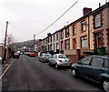
5
York Terrace, Miskin
The five houses nearest the camera are York Terrace, a separately named and numbered part of York Street. Miskin Primary School http://www.geograph.org.uk/photo/3920354 faces the houses in York Terrace and York Street.
Image: © Jaggery
Taken: 30 Jan 2014
0.05 miles
6
30 to 20 along York Street, Miskin
The 20mph maximum speed zone around Miskin Primary School http://www.geograph.org.uk/photo/3920354 starts here.
Image: © Jaggery
Taken: 30 Jan 2014
0.06 miles
7

Wall postbox, Clarence Street, Miskin
The postbox http://www.geograph.org.uk/photo/3920393 is from the reign of King George V.
Image: © Jaggery
Taken: 30 Jan 2014
0.06 miles
8

King George V wall postbox, Clarence Street, Miskin
Located here. http://www.geograph.org.uk/photo/3920390
Image: © Jaggery
Taken: 30 Jan 2014
0.06 miles
9
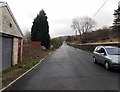
York Street, Miskin
Looking SSE along the semi-rural northern part of York Street.
Image: © Jaggery
Taken: 25 Jan 2014
0.07 miles
10
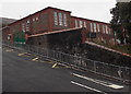
Miskin Primary School
Viewed across York Street.
Image: © Jaggery
Taken: 30 Jan 2014
0.07 miles