IMAGES TAKEN NEAR TO
Halt Road, ABERDARE, CF44 9UW
Introduction
This page details the photographs taken nearby to Halt Road, CF44 9UW by members of the Geograph project.
The Geograph project started in 2005 with the aim of publishing, organising and preserving representative images for every square kilometre of Great Britain, Ireland and the Isle of Man.

There are currently over 7.5m images from over14,400 individuals and you can help contribute to the project by visiting https://www.geograph.org.uk
Image Map
Images are licensed for reuse under creativecommons.org/licenses/by-sa/2.0
Notes
- Clicking on the map will re-center to the selected point.
- The higher the marker number, the further away the image location is from the centre of the postcode.
Image Listing (2 Images Found)
Images are licensed for reuse under creativecommons.org/licenses/by-sa/2.0
Image
Details
Distance
1
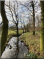
Tree-lined stream
A tributary of the Camnant, fed from the Penderyn reservoir.
Image: © Alan Hughes
Taken: 9 Nov 2020
0.09 miles
2
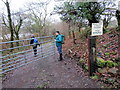
Llwybr Tyle Morgrug / Tyle Morgrug path
Cerddwyr yn dilyn llwybr cyhoeddus tuag at Ffarm Tyle Morgrug.
Walkers following a public footpath towards Tyle Morgrug Farm (trans. ants hill?).
Image: © Alan Richards
Taken: 4 Jan 2015
0.13 miles