IMAGES TAKEN NEAR TO
Halt Road, ABERDARE, CF44 9UN
Introduction
This page details the photographs taken nearby to Halt Road, CF44 9UN by members of the Geograph project.
The Geograph project started in 2005 with the aim of publishing, organising and preserving representative images for every square kilometre of Great Britain, Ireland and the Isle of Man.

There are currently over 7.5m images from over14,400 individuals and you can help contribute to the project by visiting https://www.geograph.org.uk
Image Map
Images are licensed for reuse under creativecommons.org/licenses/by-sa/2.0
Notes
- Clicking on the map will re-center to the selected point.
- The higher the marker number, the further away the image location is from the centre of the postcode.
Image Listing (7 Images Found)
Images are licensed for reuse under creativecommons.org/licenses/by-sa/2.0
Image
Details
Distance
1
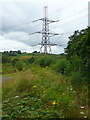
Waste ground west of Halt Road
South of Castell Farm.
Image: © Jonathan Billinger
Taken: 8 Aug 2008
0.08 miles
2
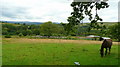
Paddock by Halt Road
Looking north-west with Fan Brycheiniog in the blue distance.
Image: © Jonathan Billinger
Taken: 8 Aug 2008
0.14 miles
4
Sticil Rhigos Stile
Llwybr cyhoeddus yn agosau at Heol Rhigos.
A public footpath approaching Rhigos Road (abundance of heather).
Image: © Alan Richards
Taken: 30 Dec 2014
0.21 miles
5
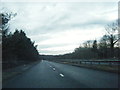
A465 westbound at dusk near Castell Farm
Image: © Colin Pyle
Taken: 17 Dec 2013
0.22 miles
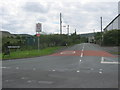
6
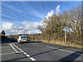
Road junction
Road junction on the road to Cefn Rhigos.
Image: © Alan Hughes
Taken: 10 Jan 2020
0.22 miles
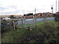
7
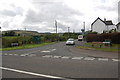
Road junction near Bryn
View looks southwards at the junction of Heol-y-Graig with the unclassified road leading to Hirwaun. A former coal mining area spoil tips are visible on the left.
Image: © Roger Davies
Taken: 8 Aug 2008
0.22 miles