IMAGES TAKEN NEAR TO
Hirwaun, ABERDARE, CF44 9TP
Introduction
This page details the photographs taken nearby to CF44 9TP by members of the Geograph project.
The Geograph project started in 2005 with the aim of publishing, organising and preserving representative images for every square kilometre of Great Britain, Ireland and the Isle of Man.

There are currently over 7.5m images from over14,400 individuals and you can help contribute to the project by visiting https://www.geograph.org.uk
Image Map
Images are licensed for reuse under creativecommons.org/licenses/by-sa/2.0
Notes
- Clicking on the map will re-center to the selected point.
- The higher the marker number, the further away the image location is from the centre of the postcode.
Image Listing (37 Images Found)
Images are licensed for reuse under creativecommons.org/licenses/by-sa/2.0
Image
Details
Distance
1
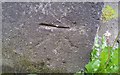
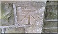
Ordnance Survey Cut Mark
This OS cut mark can be found on the north face of the Chapel. It marks a point 188.821m above mean sea level.
Image: © Adrian Dust
Taken: 12 May 2017
0.02 miles
2
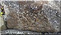
Ordnance Survey Cut Mark
This inverted OS cut mark can be found on the roadside outbuilding of Maesyrhydiau Farm. It marks a point 192.247m above mean sea level.
Image: © Adrian Dust
Taken: 12 May 2017
0.03 miles
3
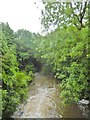
Hirwaun, Afon Cynon
Looking downstream from Station Road.
Image: © Mike Faherty
Taken: 11 Jul 2016
0.07 miles
4
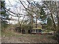
Industrial remains in Hirwaun
What appear to be lime kilns (plus a not-so-old trailer).
Image: © Gareth James
Taken: 24 Feb 2017
0.07 miles
5
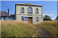
Nebo Chapel, Hirwaun
Nebo Chapel on Swansea Road, Hirwaun. Closed in July 2007.
Image: © Darren W Rees
Taken: 28 Jul 2008
0.09 miles
7
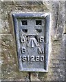
Ordnance Survey Flush Bracket (S1280)
This OS Flush Bracket can be found on the west angle of St Lleurwg's Church. It marks a point 189.629m above mean sea level.
Image: © Adrian Dust
Taken: 12 May 2017
0.11 miles
8
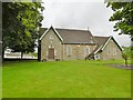
Hirwaun, St. Lleurwg's
Parish church on Station Road: http://www.parishofhirwaun.co.uk/
Image: © Mike Faherty
Taken: 11 Jul 2016
0.11 miles
9
Ordnance Survey Cut Mark
This OS cut mark can be found on the SW face of St Lleurwg's Church. It marks a point 189.847m above mean sea level.
Image: © Adrian Dust
Taken: 12 May 2017
0.12 miles
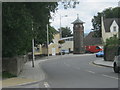
10
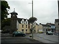
War Memorial Tower, Hirwaun
The War Memorial Tower in Hirwaun with the Cardiff Arms pub behind.
Image: © David Gentle
Taken: 14 Sep 2007
0.13 miles