IMAGES TAKEN NEAR TO
Bute Terrace, ABERDARE, CF44 9SG
Introduction
This page details the photographs taken nearby to Bute Terrace, CF44 9SG by members of the Geograph project.
The Geograph project started in 2005 with the aim of publishing, organising and preserving representative images for every square kilometre of Great Britain, Ireland and the Isle of Man.

There are currently over 7.5m images from over14,400 individuals and you can help contribute to the project by visiting https://www.geograph.org.uk
Image Map
Images are licensed for reuse under creativecommons.org/licenses/by-sa/2.0
Notes
- Clicking on the map will re-center to the selected point.
- The higher the marker number, the further away the image location is from the centre of the postcode.
Image Listing (12 Images Found)
Images are licensed for reuse under creativecommons.org/licenses/by-sa/2.0
Image
Details
Distance
2
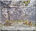
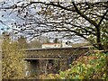
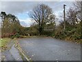
Ordnance Survey Cut Mark
This OS cut mark can be found on the SW parapet of the bridge. It marks a point 189.820m above mean sea level.
Image: © Adrian Dust
Taken: 13 Aug 2020
0.14 miles
3
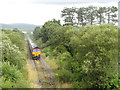
Railtour at Hirwaun
UK Railtours brought a pair of class 66 locomotives, Nos. 66011 and 66116, in top-and-tail formation, to South Wales on their Valley Legend railtour. The tour visited the Ebbw Vale and Tower Colliery branches, and is seen at Hirwaun, soon after departing Tower; with the closure of this opencast site, this may well be the last passenger train to visit the Aberdare-Tower branch.
Image: © Gareth James
Taken: 30 Jul 2017
0.18 miles
5
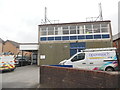
Hirwaun Telephone Exchange
Situated in Rhigos Road, this TE is of a standard design dating from the 1970s and has the code SWHJL. It provides telephone and broadband services to 3,876 residential and 120 non-residential premises in Hirwaun plus Penderyn, Penywaun and Rhigos nearby. Two Openreach vehicles can be seen parked in front of this building. The numbering range of this TE is (01685) 81xxxx, the (01685) referring to the Merthyr Tydfil of four TEs, and its postcode is CF44 9PS.
Image: © David Hillas
Taken: 23 Apr 2019
0.20 miles
7
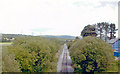
Railway bridge on the Hirwaun to Penderyn road
New road bridge over the disused railway cutting. See also Image
Image: © Alan Hughes
Taken: 9 Nov 2020
0.21 miles
8
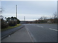
East on mineral line at Hirwaun
View eastward from the A4059 Hirwaun - Brecon road, towards Aberdare, Quaker's Yard and Pontypool Road: ex-GWR Neath - Pontypool Road line. Hirwaun station had been a little to the east: it lost its through passenger services and those on the branch to Merthyr from 15/6/64 and most freight from 1/3/65, but freight continued Hirwaun Pond - Glyn Neath until 6/11/67 and eastward traffic to Aberdare remains from Tower Colliery and the Rhigos Mountain opencast coal workings.
Image: © Ben Brooksbank
Taken: 22 Jun 2004
0.22 miles
9
The old road from Hirwaun to Penderyn
Beyond the hedge is a steep drop into a disused railway cutting. The old bridge has been removed.
Image: © Alan Hughes
Taken: 9 Nov 2020
0.22 miles
10
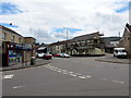
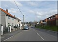
Hirwaun
Y Stryd Fawr yn cwrdd a Heol Aberhonddu ac yn y pellter mae Tafarn y Lamb.
High Street joining Brecon Road and the pub in the distance is the Lamb Inn.
Image: © Alan Richards
Taken: 24 Jun 2016
0.23 miles