IMAGES TAKEN NEAR TO
Beacons Park, ABERDARE, CF44 9QB
Introduction
This page details the photographs taken nearby to Beacons Park, CF44 9QB by members of the Geograph project.
The Geograph project started in 2005 with the aim of publishing, organising and preserving representative images for every square kilometre of Great Britain, Ireland and the Isle of Man.

There are currently over 7.5m images from over14,400 individuals and you can help contribute to the project by visiting https://www.geograph.org.uk
Image Map
Images are licensed for reuse under creativecommons.org/licenses/by-sa/2.0
Notes
- Clicking on the map will re-center to the selected point.
- The higher the marker number, the further away the image location is from the centre of the postcode.
Image Listing (52 Images Found)
Images are licensed for reuse under creativecommons.org/licenses/by-sa/2.0
Image
Details
Distance
1
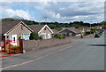
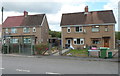
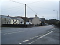
Beacons Park bungalows, Penderyn
Beacons Park is an area of bungalows south of Lamb Road.
Image: © Jaggery
Taken: 29 Jul 2012
0.01 miles
2
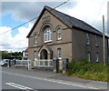
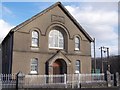
Former Capel Soar (Zoar Chapel), Penderyn
Located on the NE side of the A4059, here named Chapel Road.
The inscription (in Welsh) on a tablet above the large central window shows that this is the 1912 rebuild of the original chapel built in 1860. The chapel closed in the 1990s. It is now a private residence, Soar House
Image: © Jaggery
Taken: 29 Jul 2012
0.02 miles
3
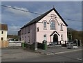
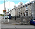
Penderyn Antiques
Housed in a former SOAR Methodist chapel: Image
Image: © Roger Cornfoot
Taken: 26 Feb 2022
0.06 miles
4
Soar chapel at Penderyn
Dating to the 1860's if I recall correctly.
Image: © Jeremy Bolwell
Taken: 27 Oct 2013
0.06 miles
5
Soar Chapel, Penderyn
Soar Chapel, Penderyn.
A stone's throw from the Lamb Inn, Penderyn.
Image: © Darren W Rees
Taken: 6 Feb 2008
0.06 miles
6
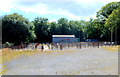
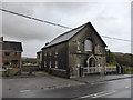
Penderyn livestock market
Located in the SW corner of Beacons Park. http://www.geograph.org.uk/photo/3059796
Image: © Jaggery
Taken: 29 Jul 2012
0.07 miles
7
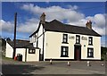
The Lamb Hotel
The Lamb Hotel, Penderyn.
Image: © Alan Hughes
Taken: 17 Sep 2016
0.07 miles
8
Rhoshyfryd houses, Penderyn
These are four semi-detached houses in Rhoshyfryd, a separately-named area alongside Chapel Road.
Image: © Jaggery
Taken: 29 Jul 2012
0.07 miles
10
Old Brecon County sign, Penderyn
Located opposite the Lamb Hotel. The sign pointing right towards Cwm Cadlan has the name Brecon County in the circle at the top. The County of Brecon (also known as Brecknockshire, the County of Brecknock or Breconshire) is one of the thirteen historic counties of Wales. The administrative county of Brecknock was abolished in 1974 by the Local Government Act 1972.
Most of the former county is now in Powys, but Penderyn is now part of the unitary authority of Rhondda Cynon Taf.
Image: © Jaggery
Taken: 29 Jul 2012
0.08 miles