IMAGES TAKEN NEAR TO
Tramway, ABERDARE, CF44 9PA
Introduction
This page details the photographs taken nearby to Tramway, CF44 9PA by members of the Geograph project.
The Geograph project started in 2005 with the aim of publishing, organising and preserving representative images for every square kilometre of Great Britain, Ireland and the Isle of Man.

There are currently over 7.5m images from over14,400 individuals and you can help contribute to the project by visiting https://www.geograph.org.uk
Image Map
Images are licensed for reuse under creativecommons.org/licenses/by-sa/2.0
Notes
- Clicking on the map will re-center to the selected point.
- The higher the marker number, the further away the image location is from the centre of the postcode.
Image Listing (37 Images Found)
Images are licensed for reuse under creativecommons.org/licenses/by-sa/2.0
Image
Details
Distance
1
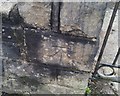
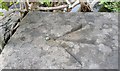
Ordnance Survey Rivet
This heavily overpainted OS rivet can be found on the window sill of No31 Merthyr Road. It marks a point 610.902ft above mean sea level.
Image: © Adrian Dust
Taken: 13 Aug 2020
0.04 miles
2
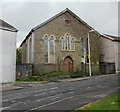
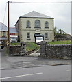
Former Mount Pleasant English Congregational Chapel, Harris Street, Hirwaun
The date 1866 is shown inside a triangular plaque on the door.
The evidence of overgrown vegetation in front of the church, broken window panes and roof tiles partly dislodged points to the building being disused.
Image: © Jaggery
Taken: 7 May 2010
0.07 miles
3
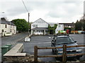
The Glancynon Inn & Restaurant, Hirwaun
Located on Swansea Road.
The Glancynon was built in 1887 as a public house and china shop. The premises were extended several times in the 1970s and modernised. The restaurant opened in 2000.
Image: © Jaggery
Taken: 7 May 2010
0.09 miles
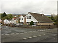
4
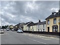
Brecon Road
Housing in Brecon Road, Hirwaun.
Image: © Alan Hughes
Taken: 24 Jul 2020
0.09 miles
5
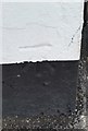
Ordnance Survey Cut Mark
This OS cut mark can be found on the wall of No11 Brecon Road. It marks a point 194.423m above mean sea level.
Image: © Adrian Dust
Taken: 13 Aug 2020
0.10 miles
6
Ordnance Survey Cut Mark
This OS cut mark can be found on the Prince of Wales. It marks a point 195.087m above mean sea level.
Image: © Adrian Dust
Taken: 12 May 2017
0.10 miles
7
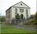
Former Nebo chapel, Hirwaun
Grade II listed building located on the north side of Merthyr Road.
Built in 1823 as Nebo Welsh Independent Chapel. A photo http://www.geograph.org.uk/photo/899713 taken in 2008, shows the building a year after the chapel closed.
Now privately owned, the building is being converted into a dwelling house. The late Georgian external appearance of the building will be retained.
Image: © Jaggery
Taken: 7 May 2010
0.10 miles
8
Ramoth Christian Centre, Hirwaun
Viewed from Davies Row. The centre's address is Bethel Place, beyond the right edge of the church.
The building was originally registered for worship as The Ramoth Particular Baptist Chapel in June 1826.
Image: © Jaggery
Taken: 7 May 2010
0.10 miles
9
Ordnance Survey Rivet
This OS rivet can be found on the north parapet of the bridge. It marks a point 179.247m above mean sea level.
Image: © Adrian Dust
Taken: 12 May 2017
0.10 miles
10
Cae Felin Parc, Hirwaun
Houses on the west side of the road, viewed from the corner of Swansea Road.
Image: © Jaggery
Taken: 7 May 2010
0.12 miles