IMAGES TAKEN NEAR TO
Glanant Street, ABERDARE, CF44 9NF
Introduction
This page details the photographs taken nearby to Glanant Street, CF44 9NF by members of the Geograph project.
The Geograph project started in 2005 with the aim of publishing, organising and preserving representative images for every square kilometre of Great Britain, Ireland and the Isle of Man.

There are currently over 7.5m images from over14,400 individuals and you can help contribute to the project by visiting https://www.geograph.org.uk
Image Map
Images are licensed for reuse under creativecommons.org/licenses/by-sa/2.0
Notes
- Clicking on the map will re-center to the selected point.
- The higher the marker number, the further away the image location is from the centre of the postcode.
Image Listing (22 Images Found)
Images are licensed for reuse under creativecommons.org/licenses/by-sa/2.0
Image
Details
Distance
1
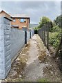
Public footpath
A public footpath passes between an old fence and a concrete wall at Hirwaun.
Image: © Alan Hughes
Taken: 24 Jul 2020
0.04 miles
3
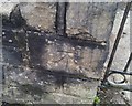
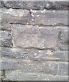
Ordnance Survey Cut Mark
This OS cut mark can be found on the wall of No11 Brecon Road. It marks a point 194.423m above mean sea level.
Image: © Adrian Dust
Taken: 13 Aug 2020
0.05 miles
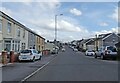
4
Brecon Road
Housing in Brecon Road, Hirwaun.
Image: © Alan Hughes
Taken: 24 Jul 2020
0.05 miles
5
Ordnance Survey Cut Mark
This OS cut mark can be found on the wall SW side of Brecon Road. It marks a point 195.587m above mean sea level.
Image: © Adrian Dust
Taken: 13 Aug 2020
0.07 miles
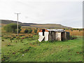
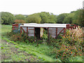
7
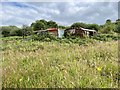
Disused railway carriages
Railway wagons once used for agricultural purposes now left to rot.
Image: © Alan Hughes
Taken: 24 Jul 2020
0.16 miles
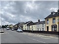
8
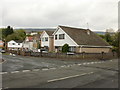
Cae Felin Parc, Hirwaun
Houses on the west side of the road, viewed from the corner of Swansea Road.
Image: © Jaggery
Taken: 7 May 2010
0.16 miles
10
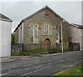
Former Mount Pleasant English Congregational Chapel, Harris Street, Hirwaun
The date 1866 is shown inside a triangular plaque on the door.
The evidence of overgrown vegetation in front of the church, broken window panes and roof tiles partly dislodged points to the building being disused.
Image: © Jaggery
Taken: 7 May 2010
0.18 miles