IMAGES TAKEN NEAR TO
Hirwaun Road, ABERDARE, CF44 9LE
Introduction
This page details the photographs taken nearby to Hirwaun Road, CF44 9LE by members of the Geograph project.
The Geograph project started in 2005 with the aim of publishing, organising and preserving representative images for every square kilometre of Great Britain, Ireland and the Isle of Man.

There are currently over 7.5m images from over14,400 individuals and you can help contribute to the project by visiting https://www.geograph.org.uk
Image Map
Images are licensed for reuse under creativecommons.org/licenses/by-sa/2.0
Notes
- Clicking on the map will re-center to the selected point.
- The higher the marker number, the further away the image location is from the centre of the postcode.
Image Listing (7 Images Found)
Images are licensed for reuse under creativecommons.org/licenses/by-sa/2.0
Image
Details
Distance

2
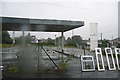
Disused filling station in Penywaun
Depressing at the best of times, more so in the teeming rain. The smudge is rain on the lens, sorry.
Image: © Graham Horn
Taken: 4 Oct 2008
0.14 miles
3
Into Ysgol Gyfun Rhydywaun, Penywaun
A view through locked school gates. http://www.geograph.org.uk/photo/4335245 Ysgol Gyfun Rhydywaun is a comprehensive school at the western edge of the village. The official language at Rhydywaun is Welsh, the language of teaching and assessment in every subject except English. All pupils study Welsh as a first language to external examination level.
Image: © Jaggery
Taken: 31 Jan 2015
0.17 miles
4
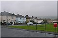
Estate in Penywaun
Trenant, in the suburb of Penywaun. The first few houses to the left and most of the green are in the north of the square.
Image: © Graham Horn
Taken: 4 Oct 2008
0.19 miles
5
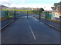
Ysgol Gyfun Rhydywaun entrance gates, Penywaun
Closed on a Saturday, the gates are across the access road to the comprehensive school located at the western edge of the village. The official language at Rhydywaun is Welsh, the language of teaching and assessment in every subject except English. Every pupil studies Welsh as a first language to external examination level.
Image: © Jaggery
Taken: 31 Jan 2015
0.19 miles
6
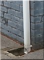
Ordnance Survey Cut Mark
This OS cut mark can be found on No 29 The Nant. It marks a point 188.138m above mean sea level.
Image: © Adrian Dust
Taken: 13 Aug 2020
0.23 miles
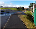
7
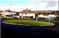
Grass roundabout near the western edge of Penywaun
The 15 metre diameter (nearly 50 feet across) roundabout it at the western end of Lawrence Avenue, at the Mangoed junction. Heading west (left) away from the roundabout is the access road to Ysgol Gyfun Rhydywaun, a Welsh language comprehensive school.
Image: © Jaggery
Taken: 31 Jan 2015
0.24 miles