IMAGES TAKEN NEAR TO
Ystradfellte, ABERDARE, CF44 9JD
Introduction
This page details the photographs taken nearby to CF44 9JD by members of the Geograph project.
The Geograph project started in 2005 with the aim of publishing, organising and preserving representative images for every square kilometre of Great Britain, Ireland and the Isle of Man.

There are currently over 7.5m images from over14,400 individuals and you can help contribute to the project by visiting https://www.geograph.org.uk
Image Map
Images are licensed for reuse under creativecommons.org/licenses/by-sa/2.0
Notes
- Clicking on the map will re-center to the selected point.
- The higher the marker number, the further away the image location is from the centre of the postcode.
Image Listing (4 Images Found)
Images are licensed for reuse under creativecommons.org/licenses/by-sa/2.0
Image
Details
Distance
1
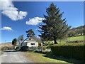
Tyr Llyn
Farm track through Tyr Llyn Farm.
Image: © Alan Hughes
Taken: 16 Apr 2021
0.01 miles
2
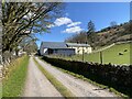
Goitre Farm
Track leading through Goitre Farm.
Image: © Alan Hughes
Taken: 16 Apr 2021
0.10 miles
3
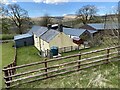
Goitre Farm
Farm on the slopes of Mynydd y Garn.
Image: © Alan Hughes
Taken: 16 Apr 2021
0.11 miles
4
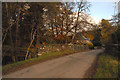
Mellte Castle and roadbridge over the River Mellte
Image: © Cedwyn Davies
Taken: 3 Nov 2007
0.24 miles