IMAGES TAKEN NEAR TO
Bryn Onnen, ABERDARE, CF44 9JA
Introduction
This page details the photographs taken nearby to Bryn Onnen, CF44 9JA by members of the Geograph project.
The Geograph project started in 2005 with the aim of publishing, organising and preserving representative images for every square kilometre of Great Britain, Ireland and the Isle of Man.

There are currently over 7.5m images from over14,400 individuals and you can help contribute to the project by visiting https://www.geograph.org.uk
Image Map
Images are licensed for reuse under creativecommons.org/licenses/by-sa/2.0
Notes
- Clicking on the map will re-center to the selected point.
- The higher the marker number, the further away the image location is from the centre of the postcode.
Image Listing (18 Images Found)
Images are licensed for reuse under creativecommons.org/licenses/by-sa/2.0
Image
Details
Distance
1
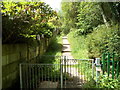
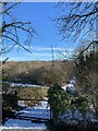
Steps up to a path, Bryn Onnen, Penderyn
Steps head away from the residential street Bryn Onnen towards a path leading to a pond and woodland.
Image: © Jaggery
Taken: 29 Jul 2012
0.02 miles
2
Tree at the far end of Bryn Onnen, Penderyn
The residential street Bryn Onnen ends at this tree at the edge of fields. http://www.geograph.org.uk/photo/3059252
Image: © Jaggery
Taken: 29 Jul 2012
0.09 miles
3
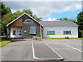
Penderyn Community Centre
Set back from the west side of Pontpren (A4059) between Bryn Onnen and Church Road.
Image: © Jaggery
Taken: 29 Jul 2012
0.10 miles
4
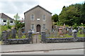
Siloam Baptist Chapel, Penderyn
Viewed across Pontpren (the A4059). A tablet in the wall above the doorway shows that the church was built in 1823, rebuilt in 1857.
Image: © Jaggery
Taken: 29 Jul 2012
0.10 miles
5
Entrance to Welsh Water site, Penderyn
Access road to Twll Turio, Penderyn.
Image: © Alan Hughes
Taken: 25 Jan 2021
0.10 miles
6
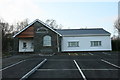
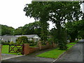
Penderyn Community Centre
The new Penderyn Community Centre, extended in 2007.
Image: © Darren W Rees
Taken: 6 Feb 2008
0.10 miles
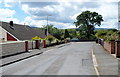
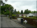
7
Pontpren houses, Penderyn
The houses are set back from the west side of the A4059, here named Pontpren.
Ahead is the residential street Llwyn Onn.
Image: © Jaggery
Taken: 29 Jul 2012
0.13 miles
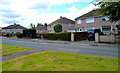
8
Woodland Park 2
A development of detached houses south of Penderyn.
Image: © Jonathan Billinger
Taken: 8 Aug 2008
0.14 miles
9
Woodland Park 1
A development of detached houses south of Penderyn.
Image: © Jonathan Billinger
Taken: 8 Aug 2008
0.17 miles
10
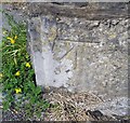
Ordnance Survey Cut Mark
This OS cut mark can be found on the gatepost of the chapel west side of the road. It marks a point 232.864m above mean sea level.
Image: © Adrian Dust
Taken: 19 Jul 2020
0.17 miles