IMAGES TAKEN NEAR TO
Pentwyn Court, ABERDARE, CF44 9ET
Introduction
This page details the photographs taken nearby to Pentwyn Court, CF44 9ET by members of the Geograph project.
The Geograph project started in 2005 with the aim of publishing, organising and preserving representative images for every square kilometre of Great Britain, Ireland and the Isle of Man.

There are currently over 7.5m images from over14,400 individuals and you can help contribute to the project by visiting https://www.geograph.org.uk
Image Map
Images are licensed for reuse under creativecommons.org/licenses/by-sa/2.0
Notes
- Clicking on the map will re-center to the selected point.
- The higher the marker number, the further away the image location is from the centre of the postcode.
Image Listing (25 Images Found)
Images are licensed for reuse under creativecommons.org/licenses/by-sa/2.0
Image
Details
Distance
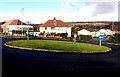
1
Mangoed, Penywaun
Looking NNW along Mangoed from the edge of this http://www.geograph.org.uk/photo/4335294 roundabout.
Image: © Jaggery
Taken: 31 Jan 2015
0.06 miles
2
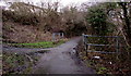
Path bridge over a brook at the edge of Penywaun
The bridge carries a footpath and cycleway from Penywaun to Hirwaun along the south bank of the Afon Cynon. The track http://www.geograph.org.uk/photo/4338879 on the left leads up to houses in Heol Bryn Gwyn.
Image: © Jaggery
Taken: 31 Jan 2015
0.08 miles
3
West along Heol Bryn Gwyn, Penywaun
The right turn is for Bryngwyn Close.
Image: © Jaggery
Taken: 31 Jan 2015
0.08 miles
4
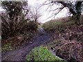
Brook and rough track, Penywaun
The brook on the right flows past the camera towards a river, Afon Cynon.
The rough track ascends from a footpath and cycleway from Penywaun to Hirwaun.
Ahead are houses in Heol Bryn Gwyn.
Image: © Jaggery
Taken: 31 Jan 2015
0.08 miles
5
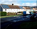
Rooftop solar panels, Lawrence Avenue, Penywaun
Viewed at the end of January 2015. A Google Earth Street View taken in June 2011 shows no solar panels here.
Image: © Jaggery
Taken: 31 Jan 2015
0.09 miles
6
East along Lawrence Avenue, Penywaun
From a grass roundabout http://www.geograph.org.uk/photo/4335294 near the western edge of the village.
Image: © Jaggery
Taken: 31 Jan 2015
0.10 miles
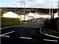
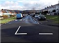
7
Grass roundabout near the western edge of Penywaun
The 15 metre diameter (nearly 50 feet across) roundabout it at the western end of Lawrence Avenue, at the Mangoed junction. Heading west (left) away from the roundabout is the access road to Ysgol Gyfun Rhydywaun, a Welsh language comprehensive school.
Image: © Jaggery
Taken: 31 Jan 2015
0.11 miles
8
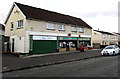
Penywaun Post Office
On the north side of a group of nine shops in the centre of Penywaun, viewed across Heol Bryn Gwyn.
The post office is flanked by Sian's Cafe on the left and Alan's General Store on the right.
Image: © Jaggery
Taken: 31 Jan 2015
0.12 miles
9
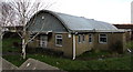
St Winifred?s church and hall, Penywaun
Looking more like a hall than a church, St Winifred's is both. The building is located on the north side of Heol Bryn Gwyn. St Winifred’s is in the Church in Wales Parish of Hirwaun, Diocese of Llandaff. The church was dedicated in 1958. A local newspaper article described it as a dual-purpose church for the Penywaun Estate, catering for the recreational as well as the spiritual needs of a large community.
Image: © Jaggery
Taken: 31 Jan 2015
0.12 miles
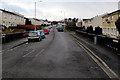
10
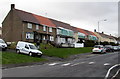
Lawrence Road, Penywaun
Viewed at the end of January 2015, during renovation or improvement work on some of the houses.
Image: © Jaggery
Taken: 31 Jan 2015
0.12 miles