IMAGES TAKEN NEAR TO
David Street, ABERDARE, CF44 8UE
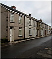
Introduction
This page details the photographs taken nearby to David Street, CF44 8UE by members of the Geograph project.
The Geograph project started in 2005 with the aim of publishing, organising and preserving representative images for every square kilometre of Great Britain, Ireland and the Isle of Man.

There are currently over 7.5m images from over14,400 individuals and you can help contribute to the project by visiting https://www.geograph.org.uk
Image Map
Images are licensed for reuse under creativecommons.org/licenses/by-sa/2.0
Notes
- Clicking on the map will re-center to the selected point.
- The higher the marker number, the further away the image location is from the centre of the postcode.
Image Listing (92 Images Found)
Images are licensed for reuse under creativecommons.org/licenses/by-sa/2.0
Image
Details
Distance
1
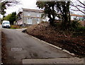
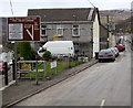
Dare Road towards David Street, Cwmdare
Near the top of a long, steep ascent from the valley of the River Dare, Dare Road approaches David Street. http://www.geograph.org.uk/photo/4336969
Image: © Jaggery
Taken: 5 Feb 2015
0.00 miles
2
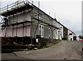
Scaffolding on David Street, Cwmdare
Side street on the east side of Dare Road.
Image: © Jaggery
Taken: 5 Feb 2015
0.02 miles
3
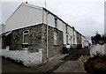
James Street, Cwmdare
Short street on the east side of Dare Road. The nameplate on the corner house shows
Colliers Arms suggesting this was formerly a pub. The exterior looks recently modernised.
Image: © Jaggery
Taken: 5 Feb 2015
0.02 miles
4

Down Dare Road, Cwmdare
Dare Road descends from Bwllfa Road towards Dare Valley Country Park.
Image: © Jaggery
Taken: 11 Feb 2019
0.07 miles
5
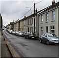
On-street parking, Bwllfa Road, Cwmdare
On the south side of Bwllfa Road. Ahead for the centre of Cwmdare.
Image: © Jaggery
Taken: 11 Feb 2019
0.08 miles
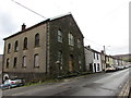
6
Eastern end of Bwllfa Road, Cwmdare
Viewed from the Dare Road junction. http://www.geograph.org.uk/photo/4338213
Image: © Jaggery
Taken: 5 Feb 2015
0.08 miles
7
Elim, Bwllfa Road, Cwmdare
The Welsh inscription https://www.geograph.org.uk/photo/6058210 on the building records that Elim Independent Chapel was built in 1859, rebuilt in 1902.
Image: © Jaggery
Taken: 11 Feb 2019
0.08 miles
8
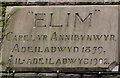
Welsh inscription, Elim, Cwmdare
The tablet on the wall here https://www.geograph.org.uk/photo/6058209 records that Elim Independent Chapel was built in 1859, rebuilt in 1902.
Image: © Jaggery
Taken: 11 Feb 2019
0.08 miles
9
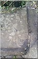
Ordnance Survey Rivet
This OS rivet can be found on the wall of the Chapel. It marks a point 224.754m above mean sea level.
Image: © Adrian Dust
Taken: 26 Aug 2019
0.08 miles
10
Row of houses in Cwmdare
On the north side of Bwllfa Road. Ahead for the centre of the village.
Image: © Jaggery
Taken: 11 Feb 2019
0.09 miles