IMAGES TAKEN NEAR TO
Holford Terrace, ABERDARE, CF44 8TP
Introduction
This page details the photographs taken nearby to Holford Terrace, CF44 8TP by members of the Geograph project.
The Geograph project started in 2005 with the aim of publishing, organising and preserving representative images for every square kilometre of Great Britain, Ireland and the Isle of Man.

There are currently over 7.5m images from over14,400 individuals and you can help contribute to the project by visiting https://www.geograph.org.uk
Image Map
Images are licensed for reuse under creativecommons.org/licenses/by-sa/2.0
Notes
- Clicking on the map will re-center to the selected point.
- The higher the marker number, the further away the image location is from the centre of the postcode.
Image Listing (113 Images Found)
Images are licensed for reuse under creativecommons.org/licenses/by-sa/2.0
Image
Details
Distance
1
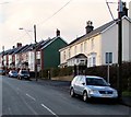
Up Cwmdare Road, Cwmdare
Looking SW along Cwmdare Road from opposite Cwmdare Mission http://www.geograph.org.uk/photo/4329696 out of shot on the right.
Image: © Jaggery
Taken: 31 Jan 2015
0.01 miles
2
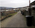
Lane alongside allotments, Cwmdare
The allotments are opposite the backs of houses in King Street.
The backs of Cwmdare Road houses are in the distance.
Image: © Jaggery
Taken: 5 Feb 2015
0.02 miles
3
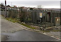
Electricity substation in Cwmdare
The Western Power Distribution electricity substation is located alongside a lane near King Street.
Its identifier is CWMDARE S/S 551984.
Image: © Jaggery
Taken: 5 Feb 2015
0.02 miles
4

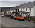
On-street parking, Holford Terrace, Cwmdare
The Holford Terrace name sign is on the right.
Image: © Jaggery
Taken: 11 Feb 2019
0.02 miles
5
Cwmdare Road houses, Cwmdare
Looking towards the Heol Brynnau junction.
Image: © Jaggery
Taken: 5 Feb 2015
0.03 miles
6
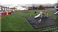
Children's playground in Cwmdare
On the east side of Holford Terrace.
Image: © Jaggery
Taken: 11 Feb 2019
0.03 miles
7
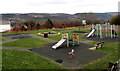
Children's play area on the east side of Cwmdare Road, Cwmdare
In a square with sides about 30 metres (100 ft) long.
Image: © Jaggery
Taken: 5 Feb 2015
0.03 miles
8
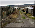
Track from King Street towards Cwmdare Road, Cwmdare
The edge of an electricity substation http://www.geograph.org.uk/photo/4341224 is on the left.
Image: © Jaggery
Taken: 5 Feb 2015
0.04 miles
9

Metal bench near Cwmd?r Primary School, Cwmdare
The school perimeter wall is behind the bench.
Image: © Jaggery
Taken: 11 Feb 2019
0.04 miles
10
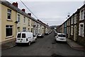
King Street, Cwmdare
Viewed from the NW end of the dead-end street looking towards Cwmdare Road.
Image: © Jaggery
Taken: 5 Feb 2015
0.04 miles