IMAGES TAKEN NEAR TO
Craig-y-Darren, ABERDARE, CF44 8PY
Introduction
This page details the photographs taken nearby to Craig-y-Darren, CF44 8PY by members of the Geograph project.
The Geograph project started in 2005 with the aim of publishing, organising and preserving representative images for every square kilometre of Great Britain, Ireland and the Isle of Man.

There are currently over 7.5m images from over14,400 individuals and you can help contribute to the project by visiting https://www.geograph.org.uk
Image Map
Images are licensed for reuse under creativecommons.org/licenses/by-sa/2.0
Notes
- Clicking on the map will re-center to the selected point.
- The higher the marker number, the further away the image location is from the centre of the postcode.
Image Listing (93 Images Found)
Images are licensed for reuse under creativecommons.org/licenses/by-sa/2.0
Image
Details
Distance
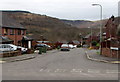
1
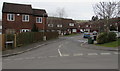
Craig y Darran, Cwmdare
Cul-de-sac on the NW side of The Ridings.
Image: © Jaggery
Taken: 5 Feb 2015
0.01 miles
2
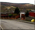
Yellow grit box and an electricity substation in The Ridings, Cwmdare
The Western Power Distribution electricity substation is set back a couple of metres
from the west side of The Ridings. Its identifier is DARREN PARK S/S 552008.
Image: © Jaggery
Taken: 5 Feb 2015
0.05 miles
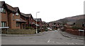
3
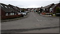
Bryn Derwen, Cwmdare
Long cul-de-sac on the NW side of The Ridings.
Image: © Jaggery
Taken: 5 Feb 2015
0.06 miles
4
Clos Bychan, Cwmdare
Cul-de-sac on the NW side of The Ridings.
Image: © Jaggery
Taken: 5 Feb 2015
0.08 miles
5
Lakeside, Cwmdare
Long cul-de-sac on the SW side of The Ridings. The far end is at the edge of the Dare Valley Country Park.
Image: © Jaggery
Taken: 5 Feb 2015
0.09 miles
6
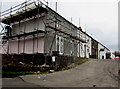
Scaffolding on David Street, Cwmdare
Side street on the east side of Dare Road.
Image: © Jaggery
Taken: 5 Feb 2015
0.10 miles
7
Cascade View, Cwmdare
Cul-de-sac on the SE side of The Ridings. Unlike in many other parts of Wales, there are no bilingual
street names in this area. A few, as Cascade View and The Ridings, are English only. Most are Welsh only.
Image: © Jaggery
Taken: 5 Feb 2015
0.10 miles
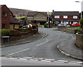
8
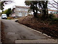
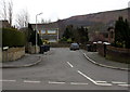
Dare Road towards David Street, Cwmdare
Near the top of a long, steep ascent from the valley of the River Dare, Dare Road approaches David Street. http://www.geograph.org.uk/photo/4336969
Image: © Jaggery
Taken: 5 Feb 2015
0.11 miles
9
Gelli Aur, Cwmdare
Cul-de-sac on the SE side of The Ridings.
Image: © Jaggery
Taken: 5 Feb 2015
0.11 miles
10
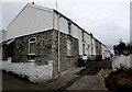
James Street, Cwmdare
Short street on the east side of Dare Road. The nameplate on the corner house shows
Colliers Arms suggesting this was formerly a pub. The exterior looks recently modernised.
Image: © Jaggery
Taken: 5 Feb 2015
0.12 miles